This album was created by a member of the TPS Teachers Network, a professional social media network for educators, funded by a grant from the Library of Congress. For more information, visit tpsteachersnetwork.org.
Immigration Maps
Album Description
New York, N.Y. Children's Colony, a school for refugee children administered by a Viennese. German refugee child, a devotee of Superman

Reference link: https://www.loc.gov/resource/ds.04108/
Reference note
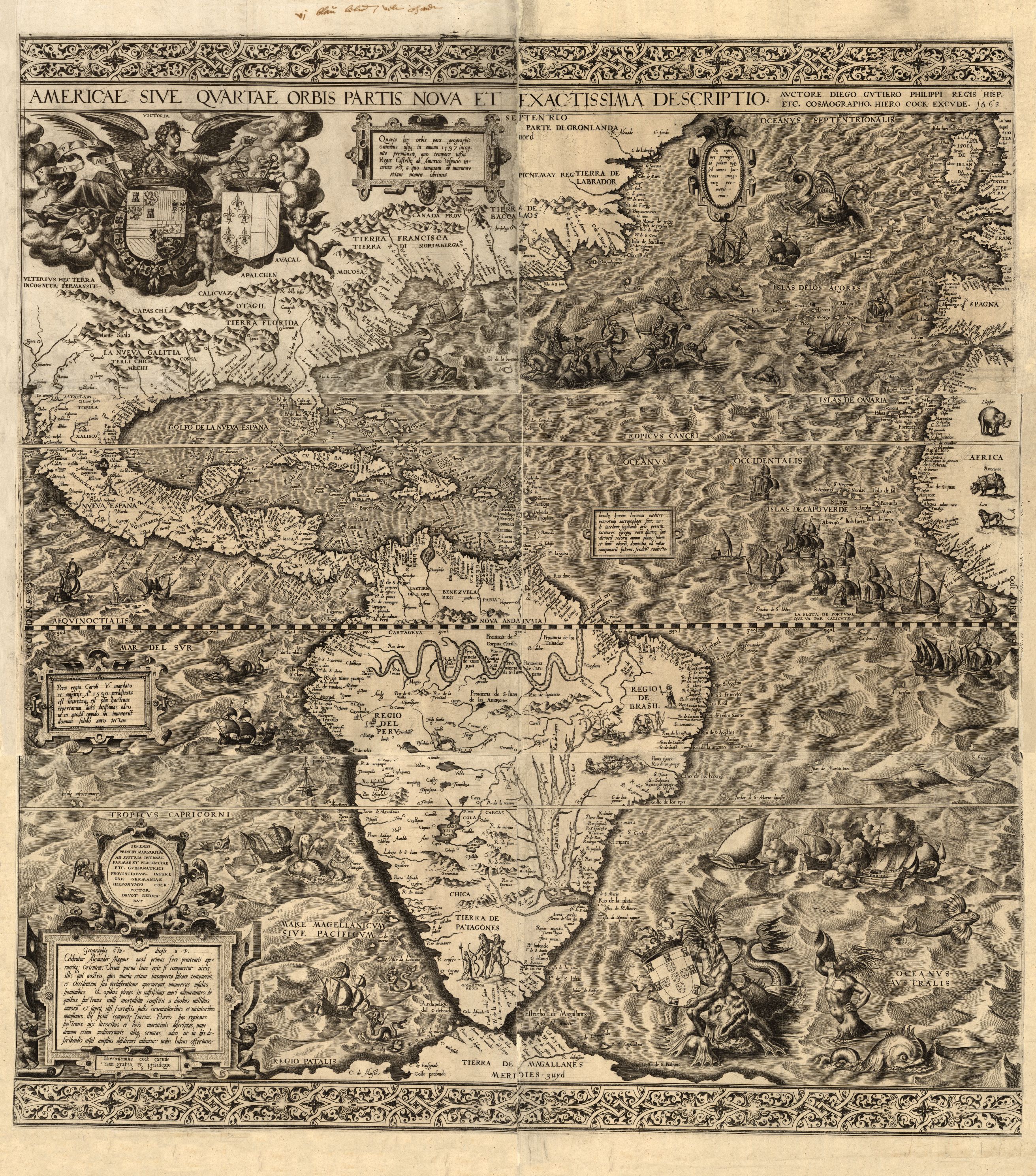
Summary: Photograph shows a boy reading a Superman comic book, issue # 19. Contributor Names: Collins, Marjory, 1912-1985, photographer Created / Published: 1942 October. Repository: Library of Congress Prints and Photographs Division Washington, D.C. 20540 USA http://hdl.loc.gov/loc.pnp/pp.printAmericae sive qvartae orbis partis nova et exactissima descriptio
Reference link: http://www.loc.gov/item/map49000970/
Reference note
Contributor Names: Gutiérrez, Diego, active 1554-1569.
Cock, Hieronymus, approximately 1510-1570.
Lessing J. Rosenwald Collection (Library of Congress)
Created / Published: [Antwerp : s.n.], 1562.
Subject Headings: - Western Hemisphere--Maps--Early works to 1800
- America--Maps--Early works to 1800
- Western Hemisphere
- America
Notes: - Covers North and South America with the adjacent seas.
- Relief shown pictorially.
- From the Rosenwald Collection, Library of Congress, no. 1303.
- Originally printed on 6 sheets.
- Described in Quarterly Journal of the Library of Congress, v. 6, no. 3 (May 1949), p. 18-20.
- Includes texts in cartouche, statements of dedication, coats-of-arms, ill. of allegorical figure "Victoria", and ill. of sailing ships at sea and imaginary marine creatures.
- Available also through the Library of Congress Web site as a raster image.
- LC sheet trimmed.
- Vault
Repository: Library of Congress Geography and Map Division Washington, D.C. 20540-4650 USA dcu
Digital Id: http://hdl.loc.gov/loc.gmd/g3290.ct000342
Auswanderer-karte und wegweiser nach Nordamerika. (Emigration Map to North America.) 1853.
Teaching Notes
In German.
How did Germans think about emigrants leaving Germany for the Americas?
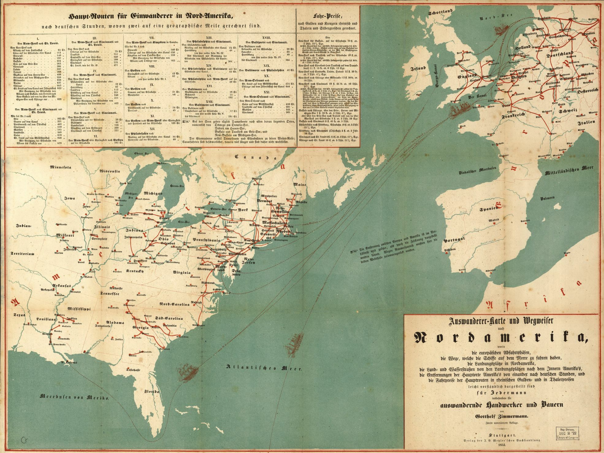
Reference link: http://www.loc.gov/item/98687132
Reference note
Contributor Names: Zimmermann, Gotthelf.
Created / Published: Stuttgart : J.B. Metzler'schen Buchh., 1853.
Subject Headings: - United States--Emigration and immigration--Maps
- Europe--Emigration and immigration--Maps
- United States
- Europe
Notes: - Available also through the Library of Congress Web site as a raster image.
Repository: Library of Congress Geography and Map Division Washington, D.C. 20540-4650 dcu
Digital Id: http://hdl.loc.gov/loc.gmd/g3701e.ct000244
Carte figurative et approximative représentant pour l'année 1858 les émigrants du globe, les pays dóu ils partent et ceux oú ils arrivent. (1858).
Teaching Notes
Map shows patterns of global immigration.
In French. How did the French view immigration?
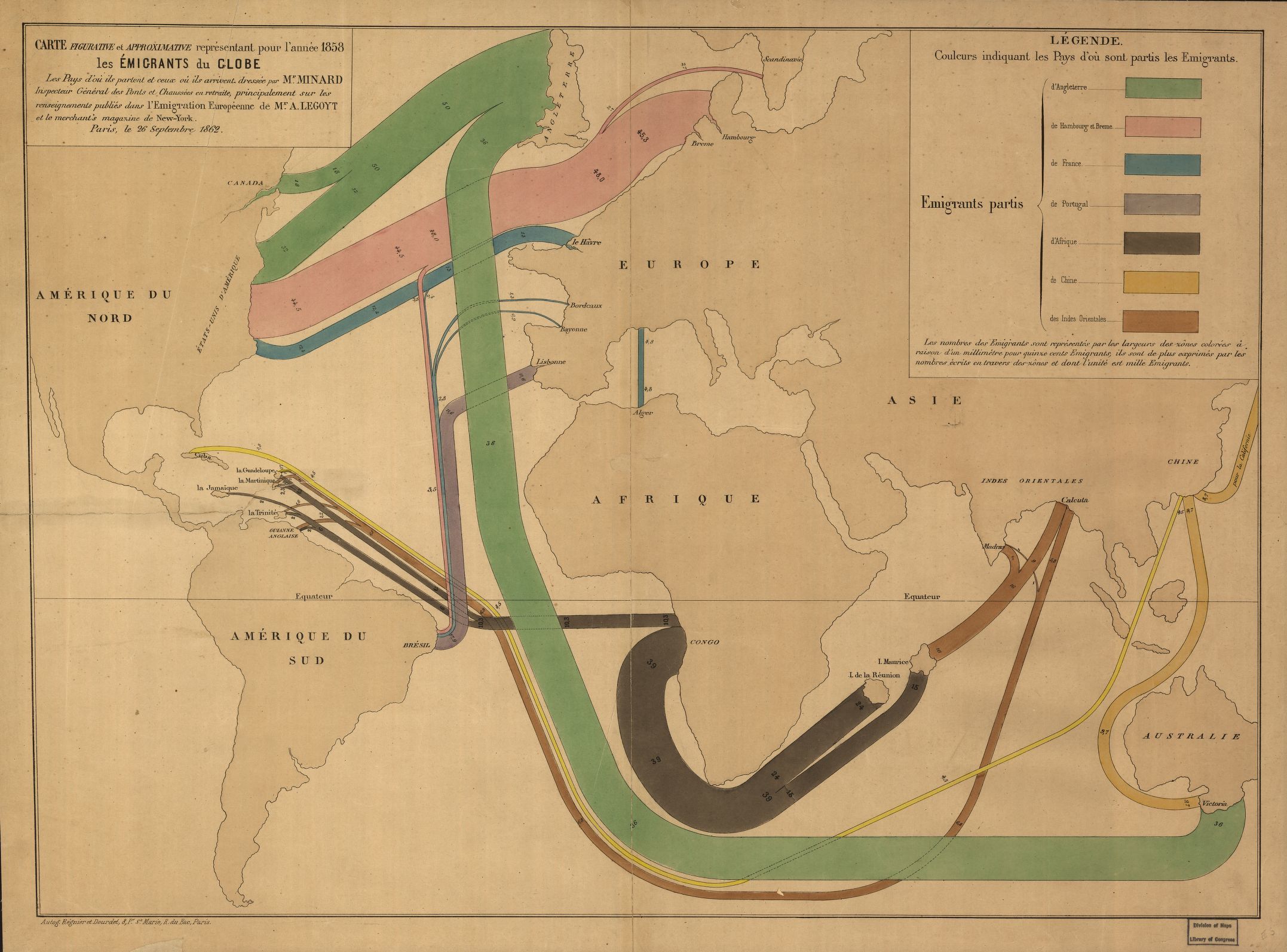
Reference link: http://www.loc.gov/item/98687134/
Reference note
Contributor Names: Minard, Charles Joseph, 1781-1870.
Legoyt, A. (Alfred), 1815-1885.
Regnier et Dourdet (Firm)
Created / Published: Paris : Charles Joseph Minard, 1862.
Subject Headings: - Emigration and immigration--Maps
- World maps
- Earth
Notes: - Fold-lined, mounted on cloth.
- Available also through the Library of Congress Web site as a raster image.
Repository: Library of Congress Geography and Map Division Washington, D.C. 20540-4650 dcu
Digital Id: http://hdl.loc.gov/loc.gmd/g3201e.ct000242
Coping with the rising tide of European immigration : [European Community countries]. CIA. 1993.
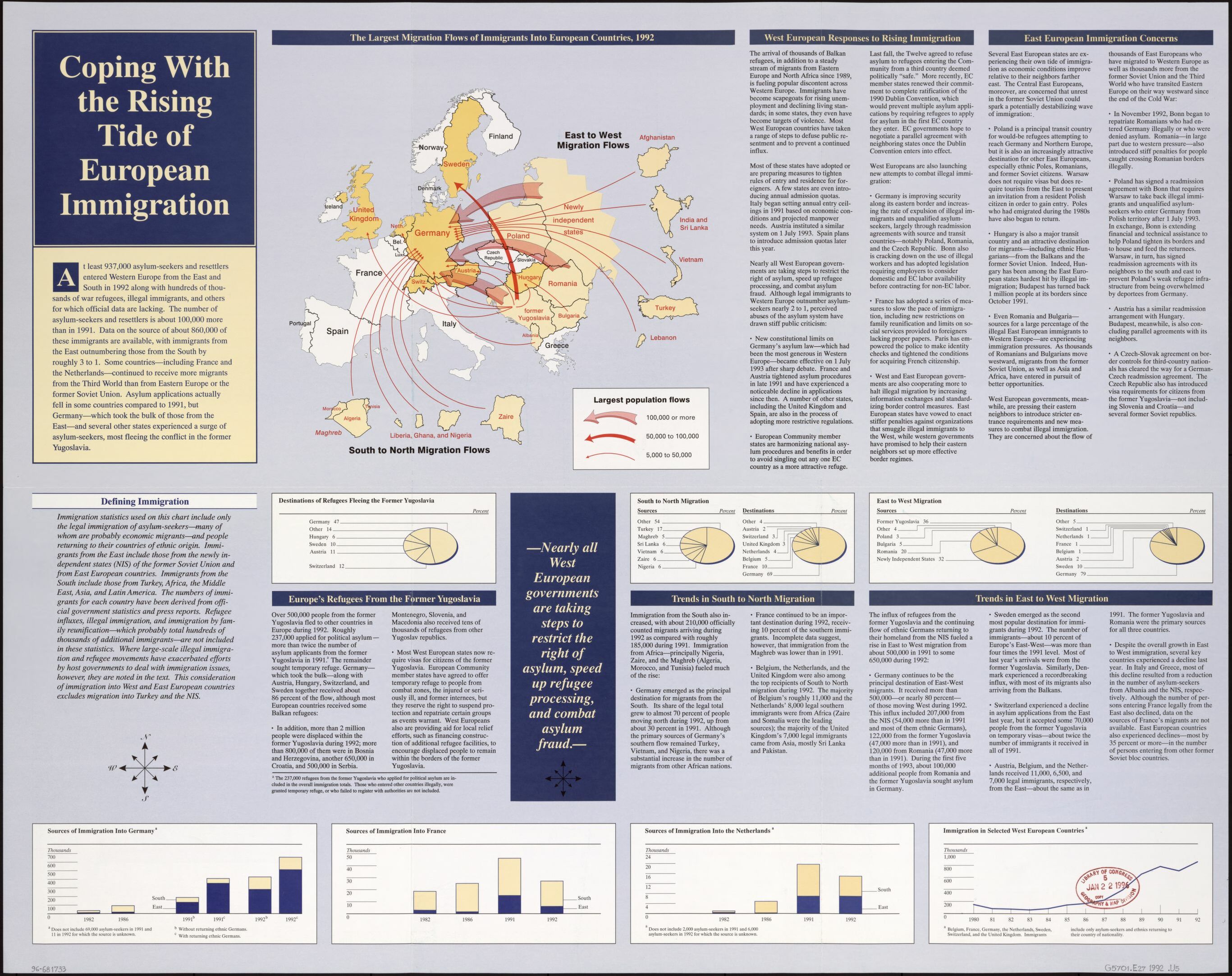
Reference link: http://www.loc.gov/item/96681733/
Reference note
Contributor Names: United States. Central Intelligence Agency.
Created / Published: [Washington, D.C. : Central Intelligence Agency, 1993?]
Subject Headings: - European Economic Community countries--Emigration and immigration--Maps
- Europe--Emigration and immigration--Maps
- Europe
Notes: - Shows legal immigration with arrows scaled to size of population flow.
- Panel title/title at upper left.
- Alternate title at top: The largest migration flows of immigrants into European countries, 1992.
- Includes text, graphs, 6 insets of "East to west migration flows," and 5 insets of "South to north migration flows."
- Title panel, directory of map distributors, and blank area on verso.
- Available also through the Library of Congress Web site as a raster image.
Repository: Library of Congress Geography and Map Division Washington, D.C. 20540-4650 USA dcu
Digital Id: http://hdl.loc.gov/loc.gmd/g5701e.ct002765
Report of the Commission Entrusted by the Council with the Study of the Frontier between Syria and Iraq. (1932).
Teaching Notes
League of Nations study of the newly carved out nations of Syria and Iraq.
Deepen understanding of this region that is in the headlines in 2019!
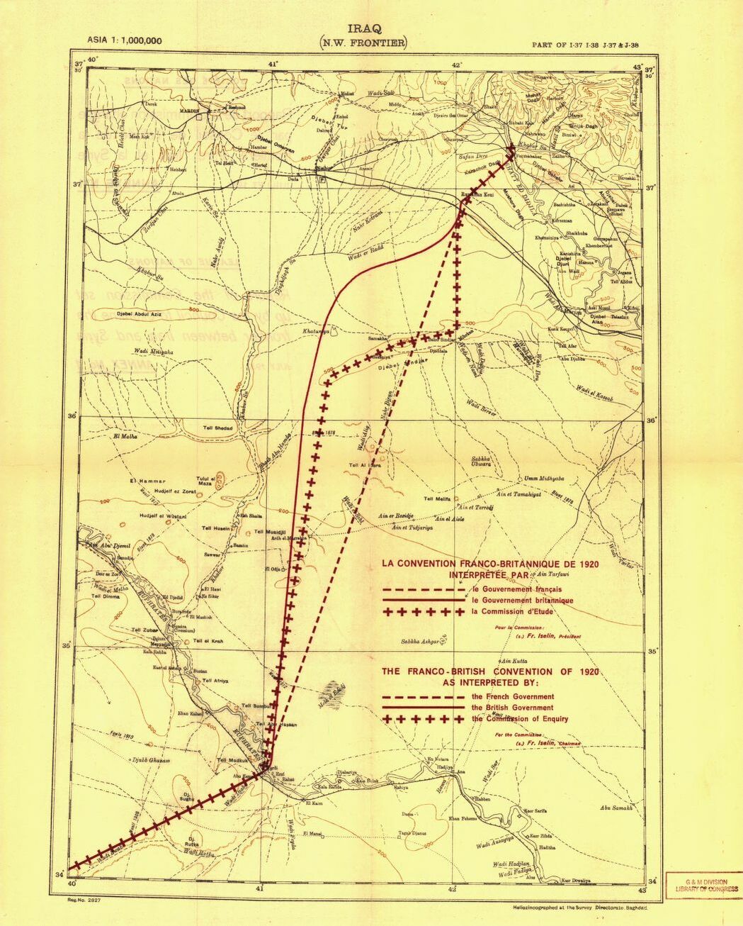
Reference link: http://www.loc.gov/item/32035610/
Reference note
Contributor Names: League of Nations. Commission Entrusted with the Study of the Frontier between Syria and Iraq.
Created / Published: [Geneva, 1932]
Subject Headings: - Syria--Boundaries--Iraq
- Iraq--Boundaries--Syria
- Syria--Boundaries--Iraq--Maps
- Iraq--Boundaries--Syria--Maps
- Syria
- Iraq
Notes: - Available also through the Library of Congress Web site as a raster image.
Repository: Library of Congress Geography and Map Division Washington, D.C. 20540-4650 USA dcu
Digital Id: http://hdl.loc.gov/loc.gmd/g7461f.ct000889a
http://hdl.loc.gov/loc.gmd/g7461f.ct000889b
http://hdl.loc.gov/loc.gmd/g7461f.ct000889c
http://hdl.loc.gov/loc.gmd/g7461f.ct000889d
Distribution of the foreign born population of the United States: 1890
Teaching Notes
Locate immigration patterns to the U.S. in the 1890s.
Where are immigrants going today? Why?
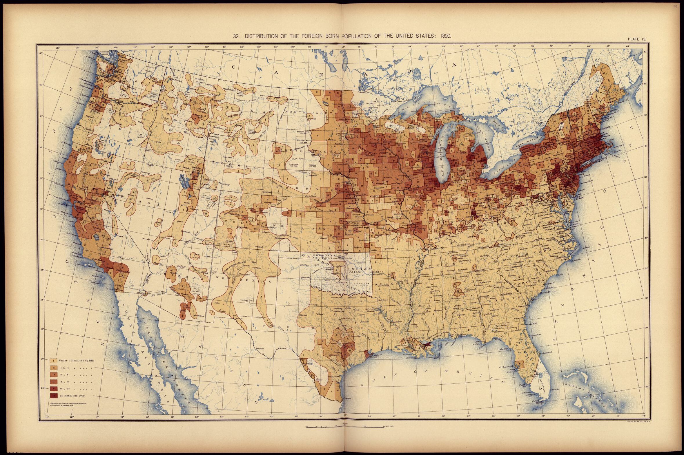
Reference link: http://www.loc.gov/resource/g3701gm.gct00010/?sp=30
Reference note
Contributor Names: United States. Census office. 11th census, 1890.
Gannett, Henry, 1846-1914.
Created / Published: Washington, Govt. print. off., 1898.
Subject Headings: - United States--Census, 1890
- United States--Statistics--Maps
- United States
Notes: - Phillips, 1333
- At head of title: Department of the interior, Census office. Robert P. Porter, superinttendent ... Carroll D. Wright, commissioner of labor in charge.
- Available also through the Library of Congress Web site as a raster image.
- Copies renumbered 4/2000. Copy 3 was made Copy 1.
Repository: Library of Congress Geography and Map Division Washington, D.C. 20540-4650 USA dcu
Digital Id: http://hdl.loc.gov/loc.gmd/g3701gm.gct00010
Immigration interactive. Includes maps of 11 different groups of Americans. Requires Flash technology.
Teaching Notes
This excellent resource allows students to explore the history and culture of many groups from around the world, including Native Americans.
Within the exhibit of any of the 11 groups, click on the globe at left to see a map showing the movement of that group in the U.S. over time.
Requires Flash technology; respond to request to download or turn on current Flash. Your computer may simply not allow use of Flash.
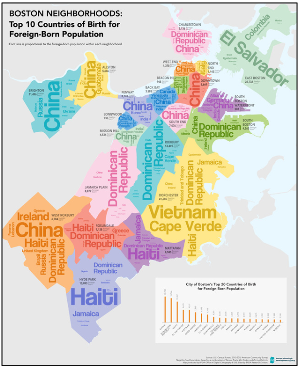
Boston neighborhoods : top 10 countries of birth for foreign-born population. (2017).
Teaching Notes
The Leventhal Map Center at the Boston Public Library created this map showing word clouds of the most common immigrant groups by neighborhood in present day Boston.
https://collections.leventhalmap.org/search/commonwealth:h989r707c
Immigrant children, Washington School. Location: Boston, Massachusetts.
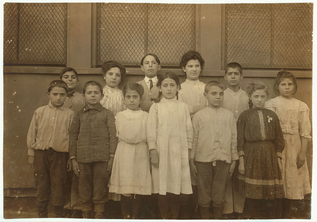
Reference link: http://www.loc.gov/item/2018674287/
Reference note
Contributor Names: Hine, Lewis Wickes, 1874-1940, photographer
Created / Published: 1909 October.
Subject Headings: - School children
- Immigrants
- Schools
- United States--Massachusetts--Boston
Genre: Photographic prints
Notes: - Title from NCLC caption card.
- Attribution to Hine based on provenance.
- In album: Miscellaneous.
- Hine no. 943.
- Credit line: National Child Labor Committee collection, Library of Congress, Prints and Photographs Division.
- General information about the National Child Labor Committee collection is available at: https://hdl.loc.gov/loc.pnp/pp.nclc
- Forms part of: National Child Labor Committee collection.
Repository: Library of Congress Prints and Photographs Division Washington, D.C. 20540 USA https://hdl.loc.gov/loc.pnp/pp.print
Digital Id: nclc 04565 https://hdl.loc.gov/loc.pnp/nclc.04565
State Proportion of the Foreign-Born Population in the United States
Teaching Notes
State Proportion of the Foreign-Born Population in the United States and Metropolitan Areas with 700,000 Foreign Born or More, 2010
Source: 2010 American Community Survey, US Census Bureau. © 2012 Migration Policy Institute