This album was created by a member of the TPS Teachers Network, a professional social media network for educators, funded by a grant from the Library of Congress. For more information, visit tpsteachersnetwork.org.
Columbia River Highlights
Album Description
A spring visit to the eastern stretch of the Columbia River was a historical and geographical eye opener! There was so much to see, so much to learn, and much pondering about why I didn't know about much about what I saw and learned. Related resources are abundant in the Library of Congress. This album includes a few historical resources representing places that caught my eye.
Some photos are already in my earlier discussion What in the Sam Hill?
 6 - 8 9 - 12 Social Studies/History Science Geology Columbia River
Multnomah Falls, Columbia River, Oregon
Teaching Notes
Multnomah Falls is the 2nd highest Waterfall in the United States. What is the highest?
Locate Multnoman Falls on a map.
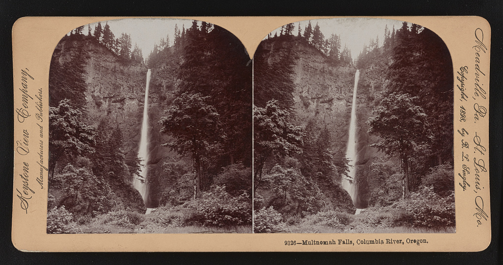
Reference link: http://www.loc.gov/item/2018650676/
Reference note
Contributor Names: Keystone View Company.
Created / Published: Meadville, Pa. ; St. Louis, Mo. : Keystone View Company, Manufacturers and Publishers, [1898]
Subject Headings: - Cliffs--Oregon--Multnomah Falls--1890-1900
- Waterfalls--Oregon--Multnomah Falls--1890-1900
- Multnomah Falls (Or.)--1890-1900
Genre: Stereographs--1890-1900
Photographic prints--1890-1900
Notes: - Copyright, 1898, by B. L. Singley.
- No. 9326.
- Title from item.
Repository: Library of Congress Prints and Photographs Division Washington, D.C. 20540 USA http://hdl.loc.gov/loc.pnp/pp.print
Digital Id: stereo 1s14780 //hdl.loc.gov/loc.pnp/stereo.1s14780
H. B. Co's. [i.e., Hudson's Bay Company's] post, Fort Vancouver, Columbia River - officers' mess house and quarters, May 1860
Teaching Notes
Officers' mess house and quarters, May 1860
How was the Fort used? How did indigenous North American people and indigenous Hwaiians help the fur traders and settlers?
Named for British North American explorer George Vancouver, the fortress was a 19th-century fur-trading post that was the headquarters of the Hudson's Bay Company's Columbia Department. There, trade goods from London were exchanged with American Indians for fur pelts.
What is Fort Vancouver today? How is it used?
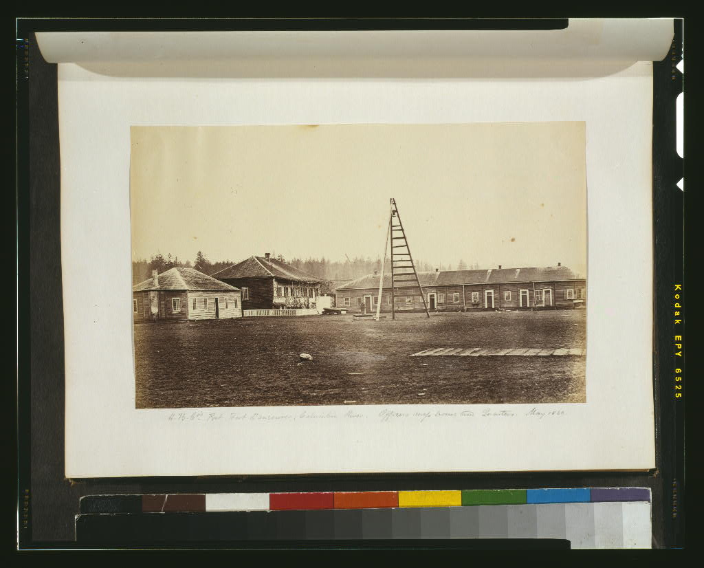
Reference link: http://www.loc.gov/item/2003663139/
Reference note
Summary: Photograph shows view officers' quarters and other buildings at the Hudson's Bay Company's post at Fort Vancouver, on the Columbia River.
Created / Published: 1860.
Subject Headings: - British North American Boundary Commission--1860
- Hudson's Bay Company--Buildings--Washington (State)--Fort Vancouver--1860
- Officers' quarters--Washington (State)--Fort Vancouver--1860
- Mess halls--Washington (State)--Fort Vancouver--1860
- Forts & fortifications--Washington (State)--Fort Vancouver--1860
- Fort Vancouver (Wash.)--1860
Genre: Albumen prints--1860
Notes: - Title from item.
- In album: [British Northwest Boundary Commission and Related Subjects, 1859-1861, leaf 10].
- Unprocessed in PR 13 CN 1999:001.01
Repository: Library of Congress Prints and Photographs Division Washington, D.C. 20540 USA
Digital Id: cph 3g11410 //hdl.loc.gov/loc.pnp/cph.3g11410
Entrance garden at Fort Vancouver, a U.S. National Historic Site along the Columbia River in Vancouver, Washington
Teaching Notes
Contemporary view of the garden at the Visitor's entrance. The garden is maintained by volunteers.
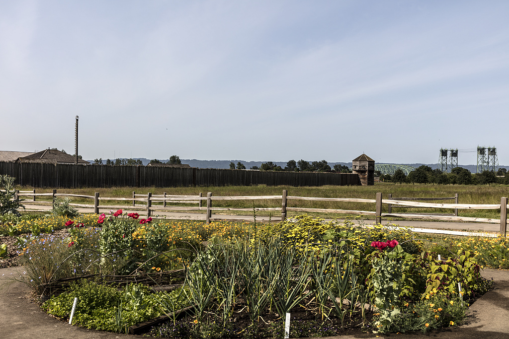
Reference link: http://www.loc.gov/item/2018699309/
Reference note
Contributor Names: Highsmith, Carol M., 1946-, photographer
Created / Published: 2018-06-06.
Subject Headings: - United States--Washington (State)--Clark County--Vancouver
- America
- Fort Vancouver
- George Vancouver
- Hudson's Bay Company
- Fur trading
Genre: Digital photographs--Color--2010-2020
Notes: - Named for British North American explorer George Vancouver, the fortress was a 19th-century fur-trading post that was the headquarters of the Hudson's Bay Company's Columbia Department. There, trade goods from London were exchanged with American Indians for fur pelts.
- Title, date and keywords based on information provided by the photographer.
- Purchase; Carol M. Highsmith Photography, Inc.; 2018; (DLC/PP-2016:103-13)
- Forms part of Carol M. Highsmith's America Project in the Carol M. Highsmith Archive.
- Credit line: Photographs in the Carol M. Highsmith Archive, Library of Congress, Prints and Photographs Division.
Repository: Library of Congress Prints and Photographs Division Washington, D.C. 20540 USA https://hdl.loc.gov/loc.pnp/pp.print
Digital Id: highsm 51107 https://hdl.loc.gov/loc.pnp/highsm.51107
The rock referenced in this sign is across the river in Washington State, but this explanation of it is on the Oregon side of the Columbia River, in Multnomah County
Teaching Notes
A sign explains the geologic and historical significance of Beacon Rock, a giant chunk of basalt in the Columbia River Gorge.
Photo of Beacon Rock National Park Service. Page includes geologic and historic information.
More information from the Columbia River Gorge web site
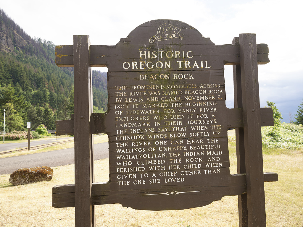
Reference link: http://www.loc.gov/item/2018699542/
Reference note
Contributor Names: Highsmith, Carol M., 1946-, photographer
Created / Published: 2018-06-09.
Subject Headings: - United States--Oregon--Multnomah County
- America
- Oregon Trail
- Columbia River Gorge
- Oregon trail signs
- Beacon Rock sign
- Signs
Genre: Digital photographs--Color--2010-2020
Notes: - Title, date and keywords based on information provided by the photographer.
- While Oregon and Washington were once part of a large U.S. territory , Oregon Trail's destination was, in fact, in what is now Oregon and marked at an end-of-the-trail site in Oregon City, near Portland. The sign is one of hundreds posted along the remnants of the famous westward trail.
- Purchase; Carol M. Highsmith Photography, Inc.; 2018; (DLC/PP-2016:103-12)
- Forms part of Carol M. Highsmith's America Project in the Carol M. Highsmith Archive.
- Credit line: Photographs in the Carol M. Highsmith Archive, Library of Congress, Prints and Photographs Division.
Repository: Library of Congress Prints and Photographs Division Washington, D.C. 20540 USA https://hdl.loc.gov/loc.pnp/pp.print
Digital Id: highsm 51340 https://hdl.loc.gov/loc.pnp/highsm.51340
Sanborn Fire Insurance Map from Astoria, Clatsop County, Oregon.
Teaching Notes
What is the significance of Fort Clatsop?
Locate Astoria on a map. Why was it a (and still is) a significant port?
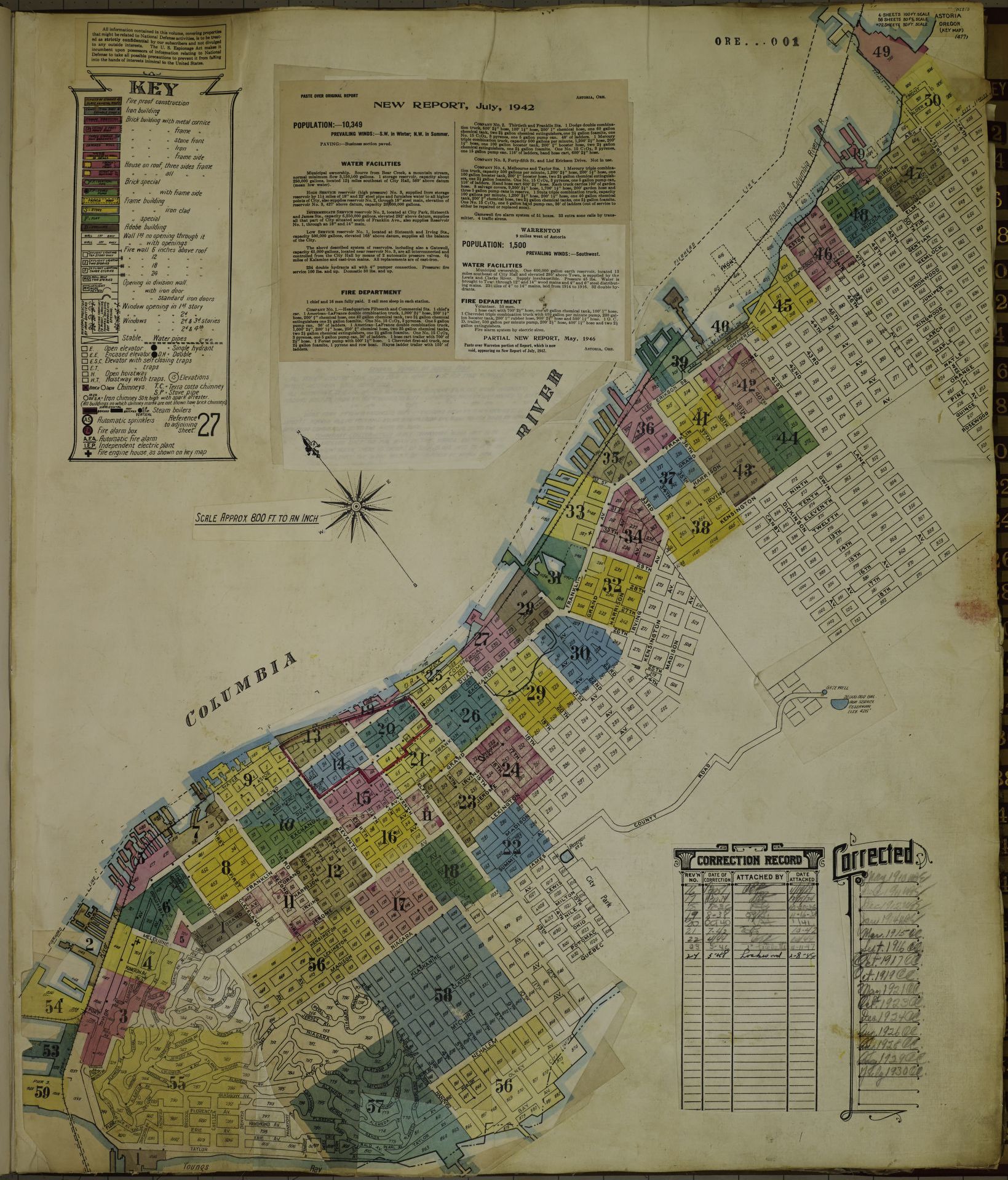
Reference link: http://www.loc.gov/item/sanborn07319_006/
Reference note
Created / Published: Sanborn Map Company, 1908 - May 1948
Notes: - 1908 - May 1948.
- 64.
- Warrenton.
- 001.
Repository: Library of Congress Geography and Map Division Washington, D.C. 20540-4650 USA
Digital Id: http://hdl.loc.gov/loc.gmd/g4294am.g4294am_g073191948
The 125-foot-tall Astoria Column, a tower overlooking the mouth of the Columbia River from a hill high above Astoria, Oregon
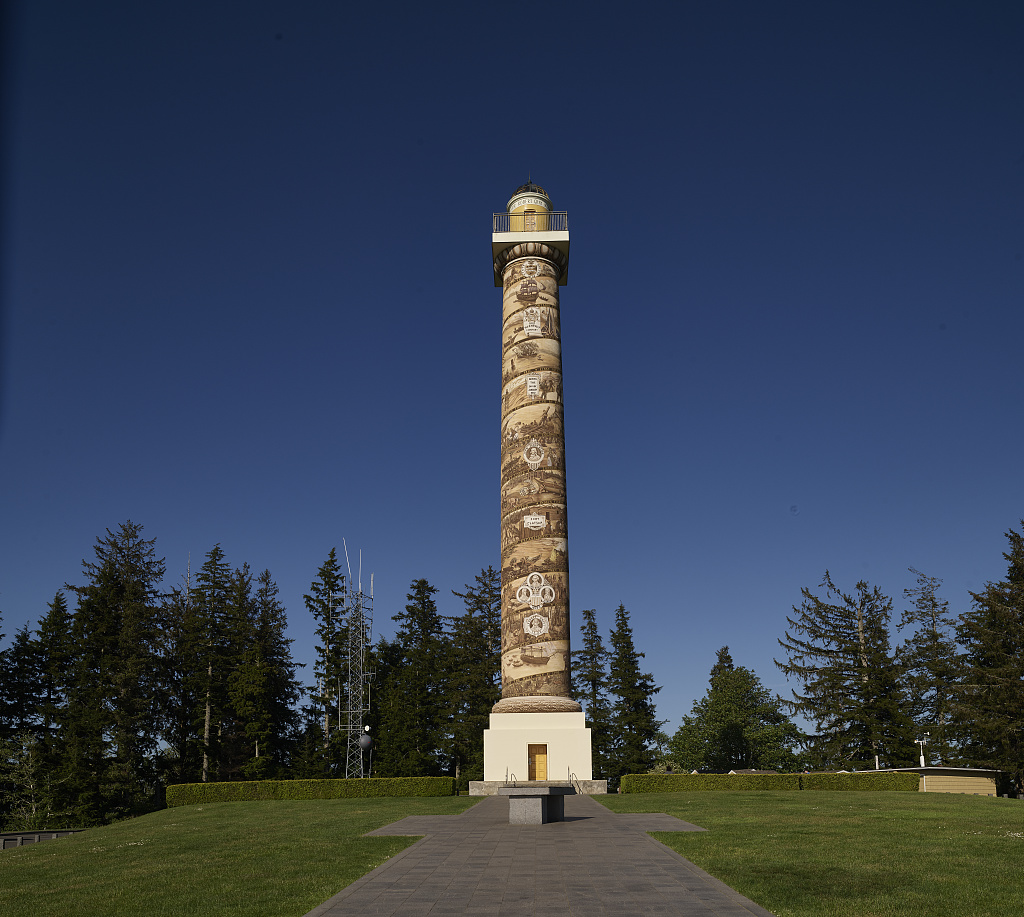
Reference link: http://www.loc.gov/item/2018698851/
Reference note
Contributor Names: Highsmith, Carol M., 1946-, photographer
Created / Published: 2018-05-21.
Subject Headings: - United States--Oregon--Astoria
- America
- Astoria Column
- Great Northern Railway
- John Jacob Astor
Genre: Digital photographs--Color--2010-2020
Notes: - Built 1926, the concrete and steel structure is covered with murals depicting voyages of discovery and settlement in the Pacific Northwest that led to the city's founding. Financed by the Great Northern Railway and a great-grandson of fur-trade baron John Jacob Astor, the tower is patterned after the Trajan Column in Rome.
- Title, date and keywords based on information provided by the photographer.
- Purchase; Carol M. Highsmith Photography, Inc.; 2018; (DLC/PP-2016:103-12)
- Forms part of Carol M. Highsmith's America Project in the Carol M. Highsmith Archive.
- Credit line: Photographs in the Carol M. Highsmith Archive, Library of Congress, Prints and Photographs Division.
Repository: Library of Congress Prints and Photographs Division Washington, D.C. 20540 USA https://hdl.loc.gov/loc.pnp/pp.print
Digital Id: highsm 50649 https://hdl.loc.gov/loc.pnp/highsm.50649
Ross's Adventures of the first settlers on the Oregon or Columbia River, 1810-1813
Teaching Notes
Adventures of the first settlers on the Oregon or Columbia River.
A Fortune Made from Fur: John Jacob Astor
Teaching Notes
This Library of Congress Blog provides historical background.
Learning about the roles Astor and the Hudson Bay Company was an "Ah" moment for me and a reminder of things not always taught in school to those of us living in another part of the United States.