This album was created by a member of the TPS Teachers Network, a professional social media network for educators, funded by a grant from the Library of Congress. For more information, visit tpsteachersnetwork.org.

    The Civil War Comes to California

    Album Description

    I'm creating an album to help students understand the role of California in the Civil War. I'd like to include the topics of the Compromise of 1850, antislavery sentiments in the state and the threat of war in the state. The reason I chose this topic is because I lead education programs at Fort Point National Historic site which is recreated to look like it appeared during the 1860s.

    The sources in the album are geared towards teachers and/or 8th grade students. I'm hoping to find ways to engage learners who might not think Civil War history is relevant in California or in their lives. 

     6 - 8   Social Studies/History  civilwar   california   slavery   antislavery   sanfrancisco   fortpoint   compromiseof1850 

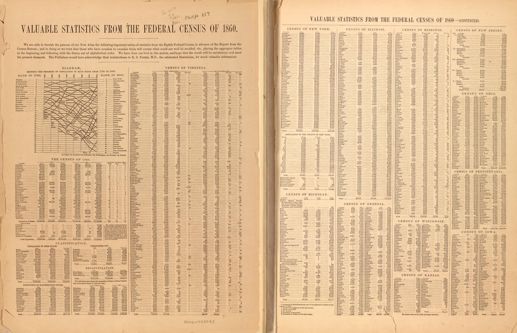
    Census statistics, 1860 - 1

    Reference note

    Created / Published

    • New York : Johnson and Ward, 1862.

    Notes

    • -  Relief shown by hachures.
    • -  LC Civil War maps (2nd ed.), 13.96
    • -  Phillips, 837
    • -  Johnson's new military map of the United States showing forts, military posts &c. with enlarged plans of southern harbors; Map 20-21, listed in LC Civil War maps (2nd ed.), 13.96.
    • -  LC copy imperfect: Brittle, with losses and repairs on edges. Half title and title page detached.

    Repository

    • Library of Congress Geography and Map Division Washington, D.C. 20540-4650 USA dcu

    Digital Id

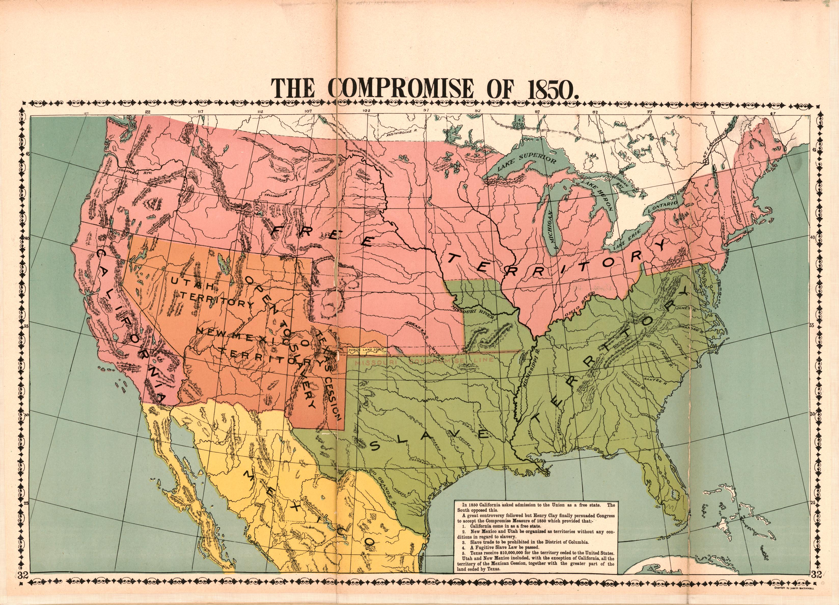
    The Compromise of 1850

    Reference note

    Created / Published

    • Chicago, Ill. : McConnell Map Co., [1919]

    Notes

    • -  Wall maps.
    • -  Relief shown by hachures.
    • -  "On each map is a brief history of the period shown."
    • -  "Copyright James McConnell"--On most maps.
    • -  Publication date inferred from rubber-stamped date: Feb. 17, 1919.
    • -  Sheet edges mounted on cloth backing.
    • -  Some maps include inset.
    • -  Maps nos. 35, 36, 37, and 38 published separately in LC Civil War Maps (2nd ed.) under entry nos. 30, 42, 51, and 76 respectively.
    • -  LC copy imperfect: Stained, deteriorated along fold lines and margins of some sheets.
    • -  LC Civil War maps (2nd ed.), 30; 42; 51; 76

    Repository

    • Library of Congress Geography and Map Division Washington, D.C. 20540-4650 USA dcu

    Digital Id

    San Francisco

    How the war commenced, and how near it is ended.

    Teaching Notes

    Title
    How the war commenced, and how near it is ended
    Creator
    National Union Executive Committee (U.S.), publisher
    Contributor
    Last, Jay T., donor
    Date Created and/or Issued
    1864
    Contributing Institution
    Huntington Library
    Collection
    Jay T. Last Collection of Graphic Arts and Social History
    Rights Information
    For information on use of Digital Library materials, please see Library Rights and Permissions: https://www.huntington.org/library-rights-permissions
    Description
    Image of a partial map of the United States with shaded areas indicating Union and Confederate territory changes during the Civil War through late 1864; text published by the National Union Executive Committee printed below the map discusses the occurrences that shaped the beginning of the war, states and territories seized with area and population, and an outline of the war's progress.
    Date based on item text. "Published by the National Union Executive Committee, Aster House, New York."--text, bottom center margin. "Who Commenced the War? ... Have we made any Progress in Crushing the Rebellion?"--text headings, center of image.
    Type
    image
    Extent
    1 letterpress : uncolored ; overall 47.63 x 30.16 cm (18 3/4 x 11 7/8 in.)
    Identifier
    priJLC_MIL_001246
    407959
    http://hdl.huntington.org/cdm/ref/collection/p16003coll4/id/2231
    Language
    English
    Subject
    Maps--Pictorial works
    United States--History--Civil War, 1861-1865
    Relief prints--1850-1875. (gmgpc)
    Broadsides. (gmgpc)
    Source
    Jay T. Last Collection
    Military
    Large Size
    American Civil War
    The Jay T. Last Collection of Graphic Arts and Social History, Huntington Digital Library

    Market Street

    Census of 1850 - California

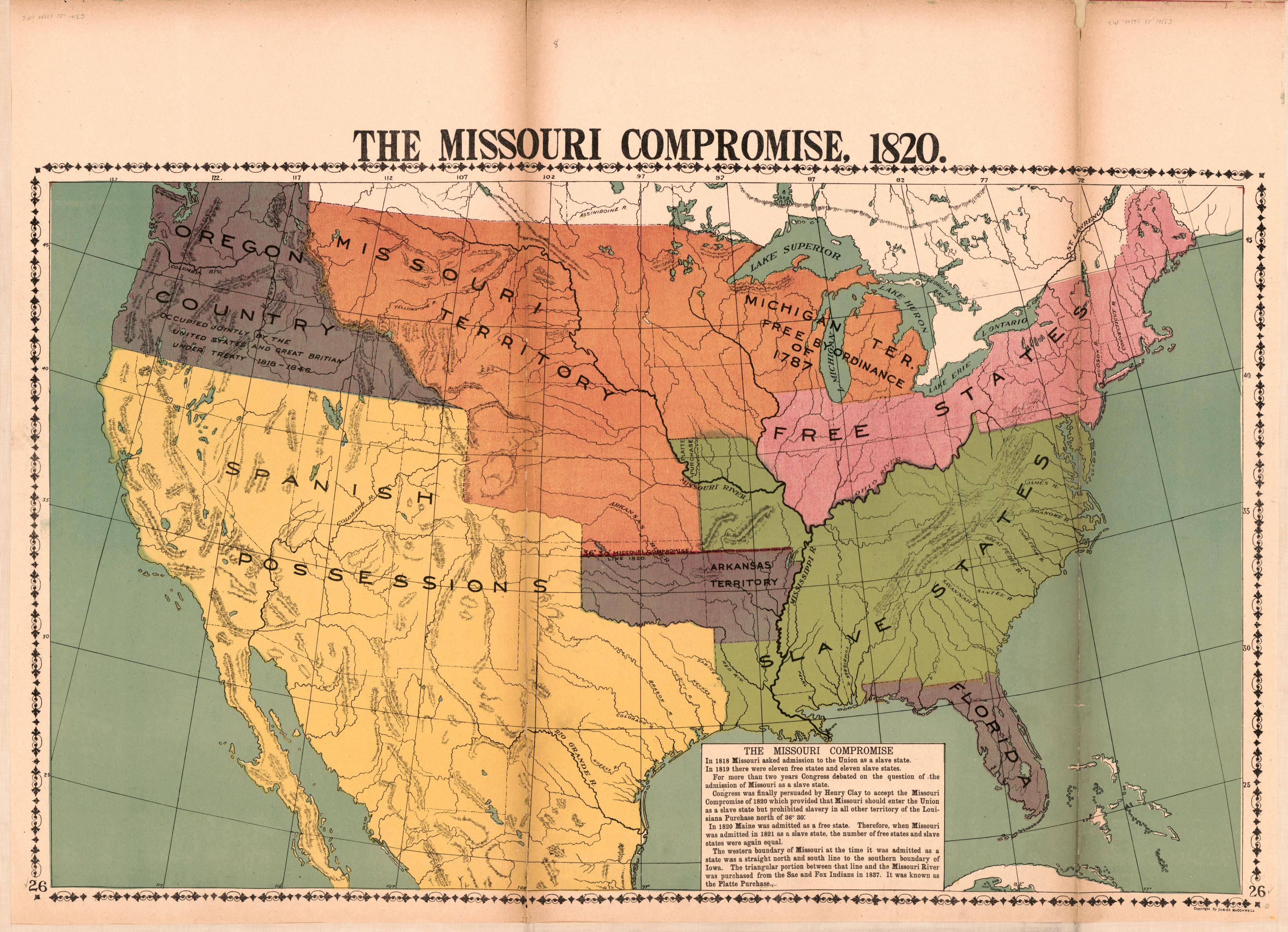
    The Missouri Compromise, 1820

    Teaching Notes

    Could be used with the Compromise of 1850 map as a way to visualize the growth of the US and the spread of slavery  6 - 8   Social Studies/History   compromiseof1820   map   missouricompromise  

    Reference note

    Created / Published

    • Chicago, Ill. : McConnell Map Co., [1919]

    Notes

    • -  Wall maps.
    • -  Relief shown by hachures.
    • -  "On each map is a brief history of the period shown."
    • -  "Copyright James McConnell"--On most maps.
    • -  Publication date inferred from rubber-stamped date: Feb. 17, 1919.
    • -  Sheet edges mounted on cloth backing.
    • -  Some maps include inset.
    • -  Maps nos. 35, 36, 37, and 38 published separately in LC Civil War Maps (2nd ed.) under entry nos. 30, 42, 51, and 76 respectively.
    • -  LC copy imperfect: Stained, deteriorated along fold lines and margins of some sheets.
    • -  LC Civil War maps (2nd ed.), 30; 42; 51; 76

    Repository

    • Library of Congress Geography and Map Division Washington, D.C. 20540-4650 USA dcu

    Digital Id