This album was created by a member of the TPS Teachers Network, a professional social media network for educators, funded by a grant from the Library of Congress. For more information, visit tpsteachersnetwork.org.

    The Trail of Tears and Indian Removal

    Album Description

    Topics: The paths Native Americans took when traveling to the reservations they were moved to. The change in land from what Native American tribes had ancestrally and pre-Trail of Tears compared to after, and the size of each reservation. The prominent figures in the displacement of Native Americans and those who fought against it within the tribes. 

    This album will contain primary and secondary sources in regard to the Trail of Tears. The Trail of Tears refers to the forced migration of hundreds of thousands of Native Americans during the 1830's and 1840's. Native American tribes were forced to leave the land them and their ancestors had occupied for centuries, and move to Indian Territory in the midwest. This album will provide teachers and students learning about the Trail of Tears and Native American displacement, likely during elementary/middle school, with sources to support learning and a deeper understanding of the events that occurred. The learners these sources can mainly be used with are 5th grade students as the Trail of Tears and the Indian Removal Act is listed under the 5th grade section of the Virginia SOL. I chose this topic as I find this time in US History particularly interesting and often not spoken about deeply, and wanted to provide myself and students more insight into the historical sources we have available thtat can educate us more on the topic.   3 - 5   6 - 8   9 - 12   Social Studies/History   Trailoftears   Nativeamerican    1800s 

    Map showing Indian reservations within the limits of the United States : 1883

    Teaching Notes

    For this source I would zoom in on the reservations present, and allow students to see how each highlighted area of reservation is not just for one tribe, but split amongst different tribes. I would also circle each separate area of land reserved for each tribe, to emphasize how small the land is. I'd hope to compare this to a map showing Native American land before being forcefully removed.   6 - 8   9 - 12   Social Studies/History   Trailoftears   Nativeamerican re  Nativeamericanreservations   map  

    Reference note

    Created / Published

    • [Washington, DC?] : [s.n.], 1883.

    Notes

    • -  Prime meridians: Washington, D.C. and Greenwich.
    • -  Inset of Indian Territory in Northeastern Oklahoma. 6 x 6 cm.
    • -  LC copy mounted on cloth.
    • -  LC copy imperfect: tear in upper, middle portion of map.

    Repository

    • Library of Congress Geography and Map Division Washington, D.C. 20540-4650 USA dcu

    Digital Id

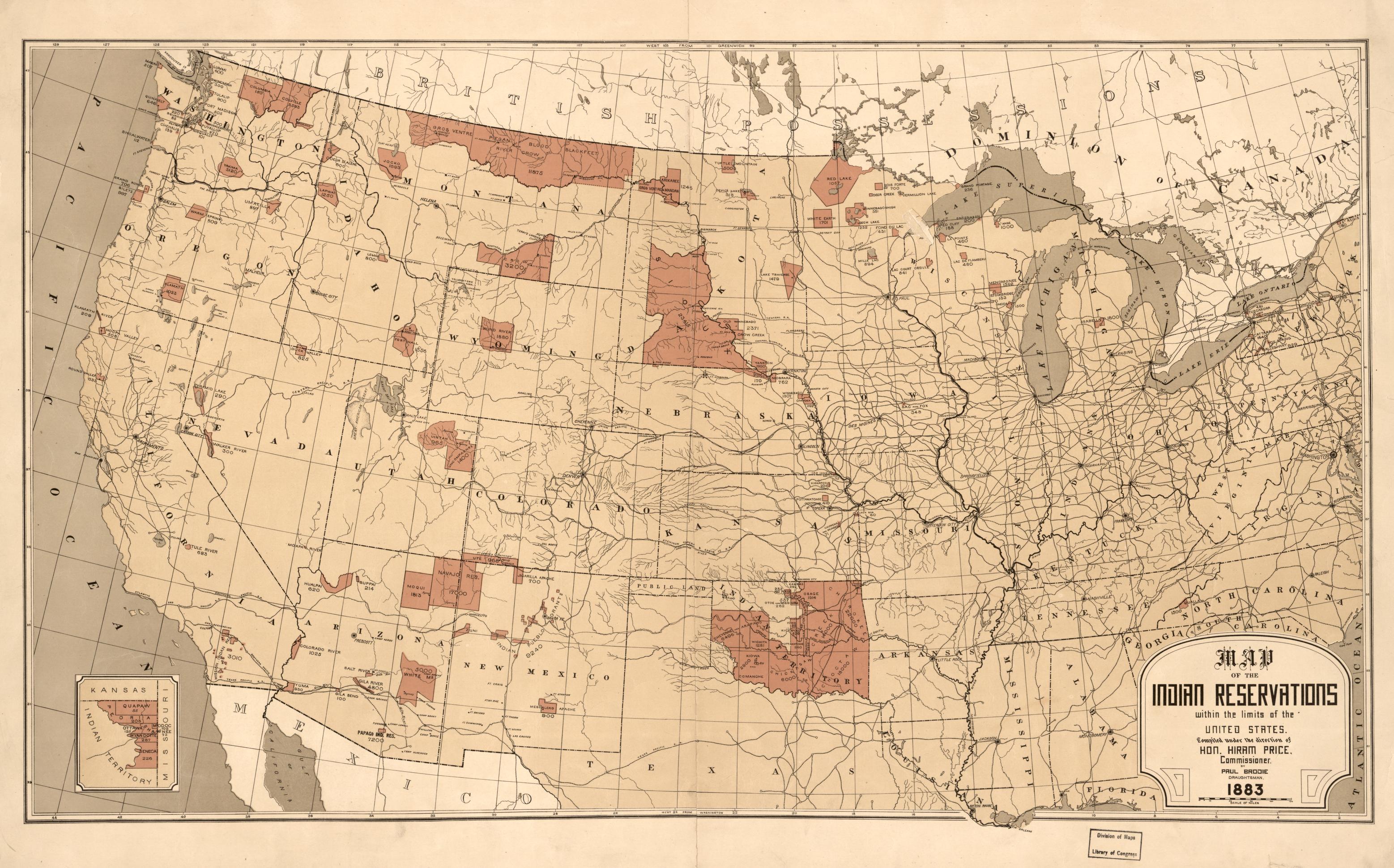
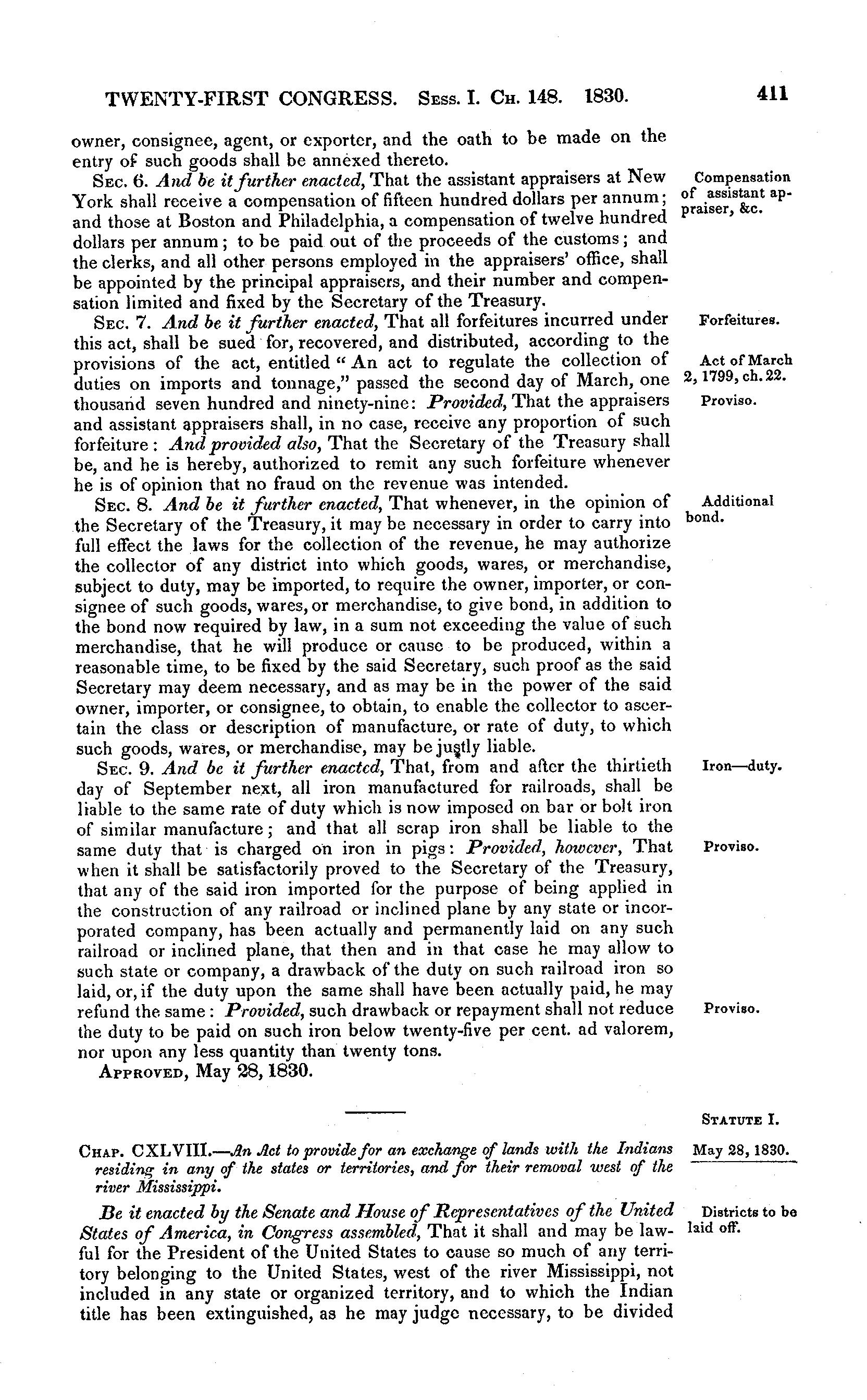
    Image 459 of U.S. Statutes at Large, Volume 4 (1824-1835), 19th through 23rd Congress.

    Teaching Notes

    Image 459-460 shows the Indian Removal Act signed into law by President Andrew Jackson on May 28, 1830, which approved the forced relocation of Native American tribes. I would have students highlight or annotate the related sections as we begin learning about what led to the Trail of Tears.

    Reference note

    Created / Published

    • United States, 1826 - 1835

    Genre

    • Periodical

    Repository

    • Law Library Of Congress

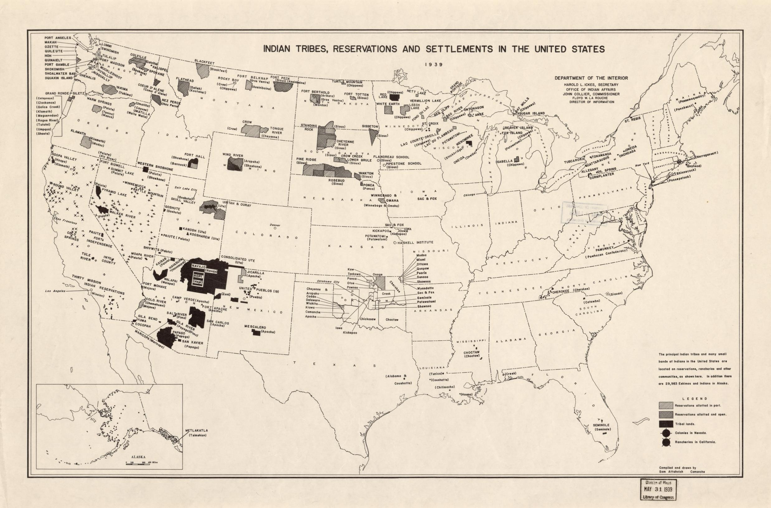
    Indian tribes, reservations and settlements in the United States
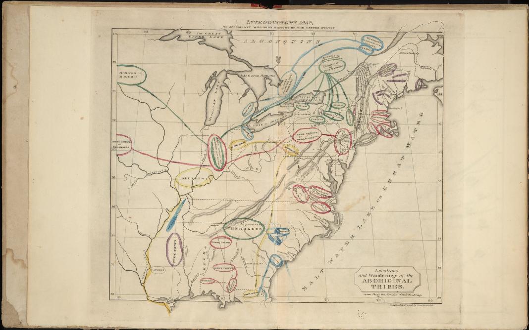
    Teaching Notes

    I would ask students to notice and wonder with this map. It depicts both Native American reservations as well as their ancestral land, giving students much to think about, and leading to a conversation about why they are different. 

    Reference note

    Created / Published

    • [Washington, D.C.] : Dept. of the Interior, Office of Indian Affairs, 1939.

    Notes

    • -  Inset: Alaska. [Scale ca. 1:32,186,880]. 7 x 12 cm.

    Repository

    • Library of Congress Geography and Map Division Washington, D.C. 20540-4650 USA dcu

    Digital Id

    Introductory Map

    Teaching Notes

    This map depicts Native American land before the Indian Removal Act was signed into law. I would have students list what they notice about this image and compare it to maps after the act was signed into law as a compare activity. 

    Reference note

    Created / Published

    • New York, White, Gallaher, & White, 1828.

    Genre

    • Atlases

    Notes

    • -  Maps no. 4 and 6 show revisions ("Third map" and "Fifth map").

    Repository

    • Library of Congress Geography and Map Division Washington, D.C. 20540-4650 USA dcu

    Digital Id

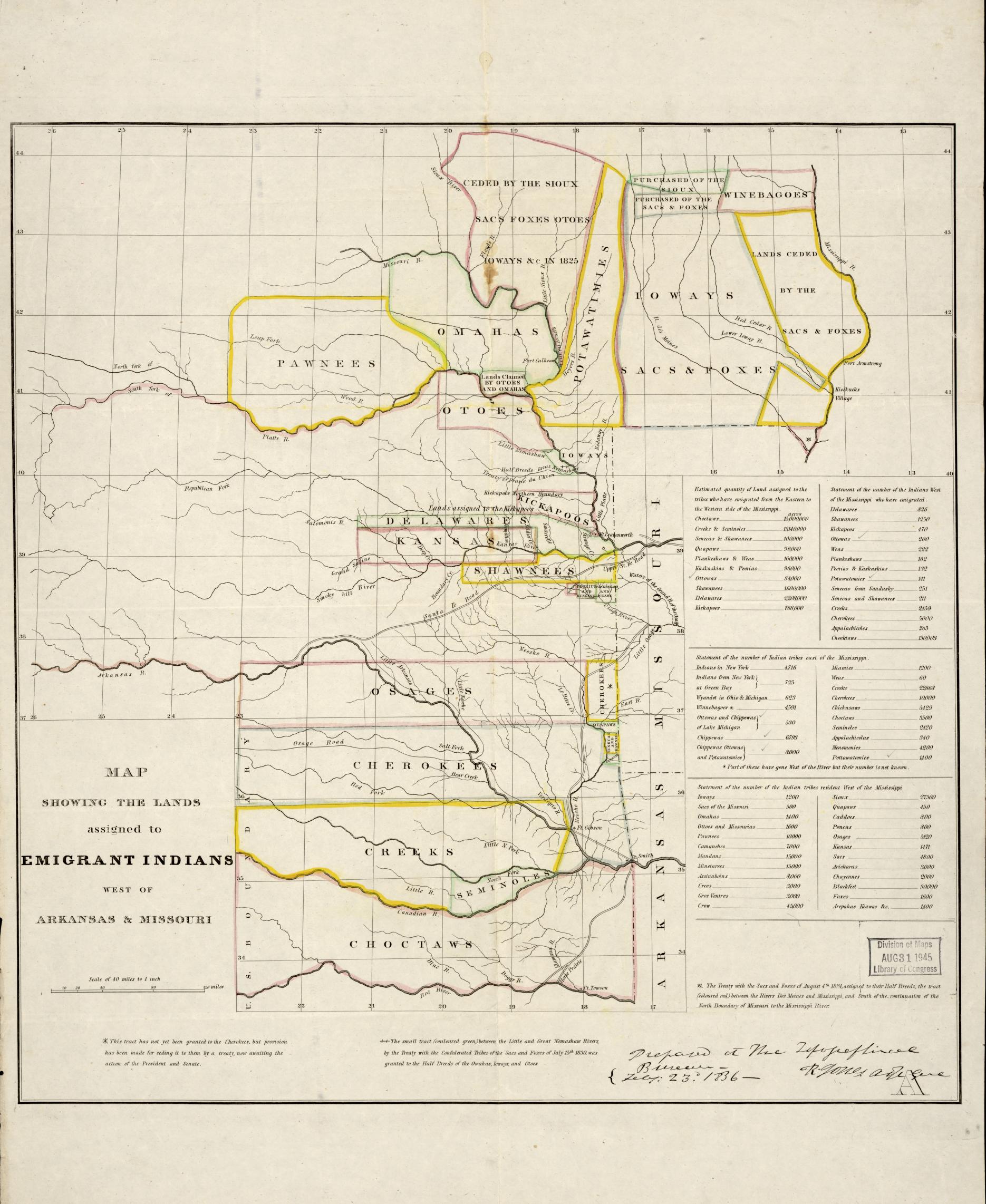
    Map showing the lands assigned to emigrant Indians west of Arkansas and Missouri.

    Teaching Notes

    This map shows the land assigned to Native American tribes after the Indian Removal Act. I would have students think of something surprising, interesting, and troubling about this map.

    Reference note

    Created / Published

    • [S.l.], 1836.

    Notes

    • -  From: [Documents concerning Col. Henry Dodge's expedition to the Rocky Mountains], House Document 181, 24th Cong., 1st session, 1835-36, serial 289.
    • -  LC Many nations, 200
    • -  Exhibition: Indians of North America, Library of Congress, Washington, D.C., August, 1977.

    Repository

    • Library of Congress Geography and Map Division Washington, D.C. 20540-4650 dcu

    Digital Id

    Trail of Tears: Routes, Statistics, and Notable Events- Britannica

    Teaching Notes

    This infographic highlights the routes on the Trail of Tears many Native Americans traveled on as they were forced to relocate West. I would have students do a Question Formulation Technique with this source before using their questions to build on with a discussion. 

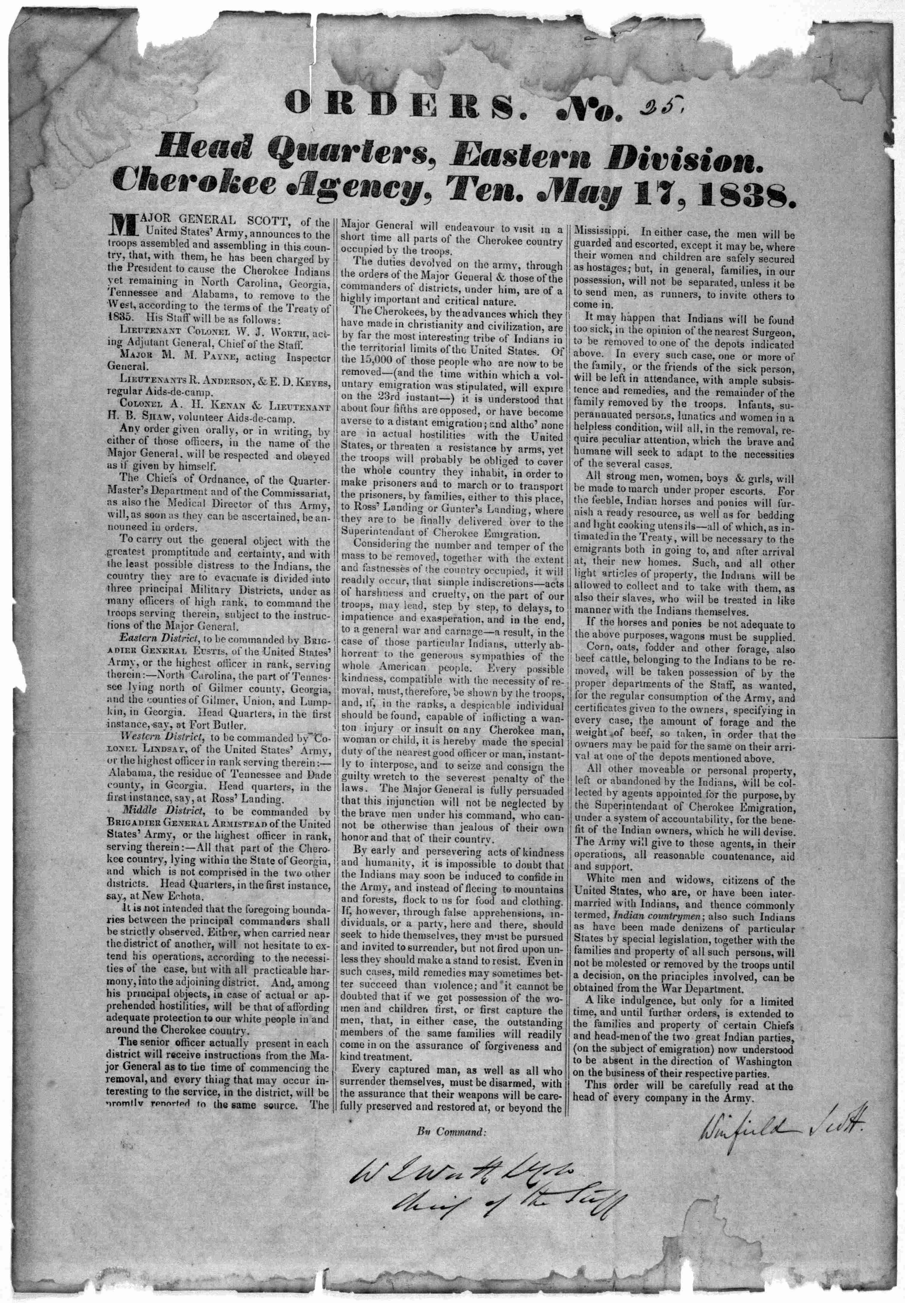
    Orders No. [25] Head Quarters, Eastern Division Cherokee Agency, Ten. May 17, 1838. [n. p. 1838].

    Teaching Notes

    I would have students highlight key parts of this primary source to try and decipher and understand the intent behind it and what it is. 

    Reference note

    Created / Published

    • 1838.

    Genre

    • Broadsides--Tennessee

    Notes

    • -  Printed Ephemera Collection; Portfolio 174, Folder 40a.

    Digital Id

    Cherokee phoenix, and Indians' advocate. [volume], March 03, 1830, Image 4

    Teaching Notes

    I would have students work in groups analyzing one of the articles related to Indian communities and removal seen in the newspaper. I would have students share what their article was about and what it can tell us about relations at that time.

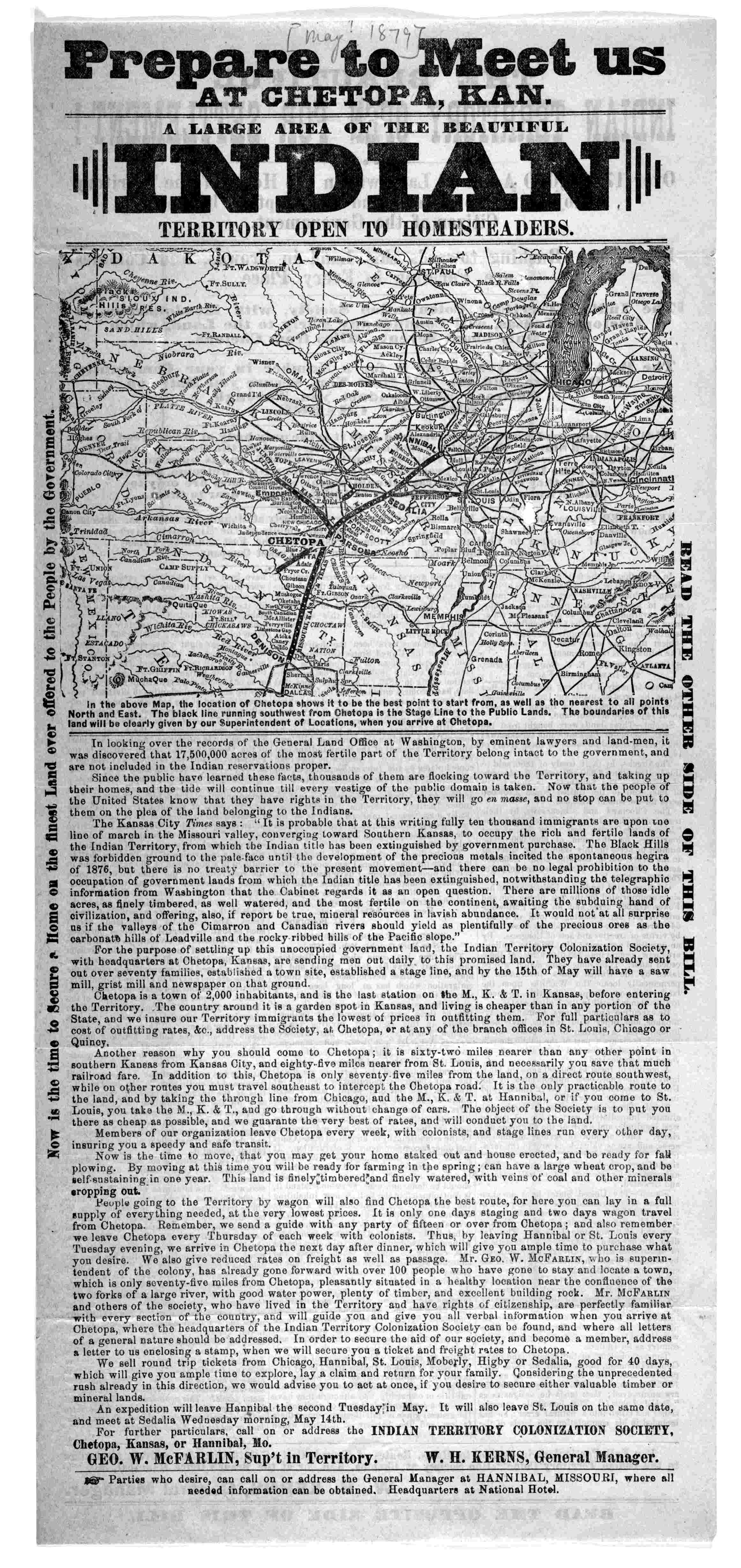
    Prepare to meet us at Chetopa, Kan. a large area of the beautiful Indian territory open to homesteaders ... for further particulars, call on or address the Indian Territory Colonization Society [1879].

    Teaching Notes

    I would have students do a think-pair share about what they think the purpose of this article is and what it is describing. 

    Reference note

    Created / Published

    • Chetopa, 1879.

    Genre

    • Advertisements--Kansas--Chetopa

    Notes

    • -  Title.; Public lands.
    • -  Printed Ephemera Collection; Portfolio 20, Folder 19.

    Digital Id

    A letter from President Andrew Jackson to the Cherokee Nation about the benefits of voluntary removal, March 16, 1835

    Teaching Notes

    I would have students annotate this document to analyze the relations between Native American nations and White communities before the Indian Removal Act.

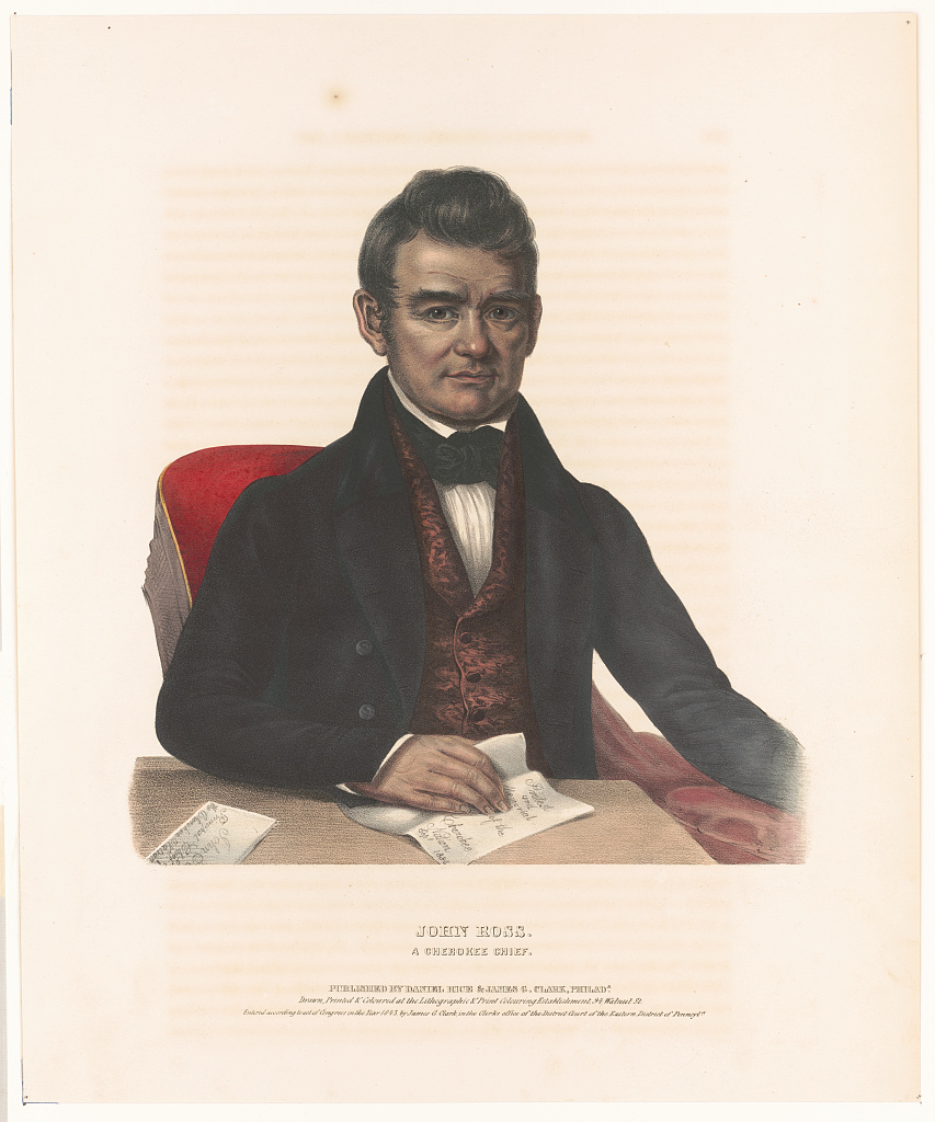
    John Ross, a Cherokee chief / drawn, printed & coloured at the Lithographic & Print Colouring Establishment, 94 Walnut St.

    Teaching Notes

    I would have students do a notice and wonder about who this image depicts and what they might've believed in. 

    Reference note

    Summary

    • Print shows John Ross, half-length portrait, seated, facing front, with right hand on a paper that states "Protest and Memorial of the Cherokee Nation Sept. 1836".

    Created / Published

    • Philada. : Published by Daniel Rice & James G. Clark, c1843.

    Genre

    • Portrait prints--1840-1850
    • Lithographs--Hand-colored--1840-1850

    Notes

    • -  Title from item.
    • -  Entered according to act of Congress in the year 1843, by James G. Clark, in the Clerks office of the District Court of the Eastern District of Pennsyla.

    Repository

    Digital Id

    Children's Book: Trail of Tears- Step Into Reading by Joseph Bruchac

    Children's Book: Soft Rain: A Story of the Cherokee Trail of Tears by Cornelia Cornelissen

    Children's Book: Longwalker's Journey by Beatrice Orcutt Harrell

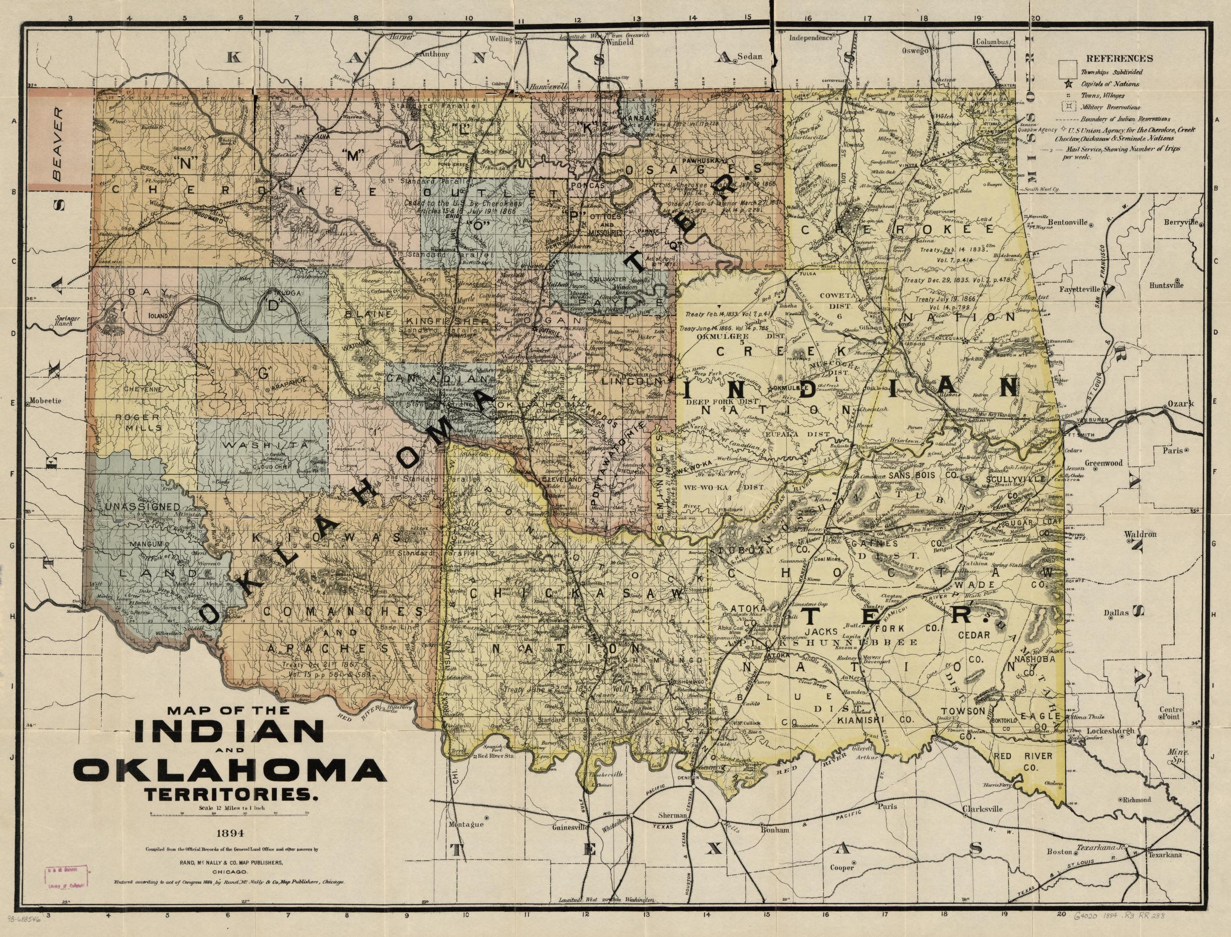
    Map of the Indian and Oklahoma territories, 1894; compiled from the official records of the General Land Office and other sources.

    Reference note

    Summary

    • Shows relief by hachures, drainage, Indian areas, districts, treaty dates, roads and trails, and the named railroads.

    Created / Published

    • Chicago, 1894, c1884.

    Notes

    • -  Scale 1:760,320.
    • -  LC Railroad maps, 288
    • -  Description derived from published bibliography.
    • -  Includes index guide.

    Repository

    • Library of Congress Geography and Map Division Washington, D.C. 20540-4650 USA dcu

    Digital Id