This album was created by a member of the TPS Teachers Network, a professional social media network for educators, funded by a grant from the Library of Congress. For more information, visit tpsteachersnetwork.org.
Geography Aligned Railroad Resources for the study of Westward Expansion
Album Description
Contextual Paragraph:
The discovery of gold in California in 1848 inspired a massive human migration first in a westward direction and subsequently eastward from there to Nevada and Colorado where later discoveries were made. The travels of the first gold seekers were difficult and time consuming as the choices for easterners to travel to the gold fields were overland by wagon trains or by sea; the Atlantic Ocean to the Isthmus of Panama, overland to the Pacific Ocean sailing northward to California.
Travelers who crossed the Great Plains and traversed the Rocky Mountains began to realize that perhaps there was value in something other than gold and later silver. As the population in the western territories grew, both sections realized that a better transportation system, e.g. railroads, would greatly benefit the economies of both sections.
Passage of the Homestead Act (1862) and the Transcontinental Railroad Acts of 1862 and 1864 set the stage for the development of the western United States in the latter half of the 19th century.
Geographic Thinking Skill(s):
- Analyze how historical events and the spatial diffusion of ideas, technologies, and cultural practices have influenced migration patterns and the distribution of the human population.
- Evaluate how political and economic decisions influence cultural and environmental characteristics of various places and regions.
Essential Question:
- How did railroads affect the development of the western United States in the last half of the 19th Century?
Grade Level:
- Middle/High School
Created in Collaboration with the TPS Western Region and Geo Alliance Partners in AZ, CO, NV, and OR.
Special Thanks to  Cynthia Stout
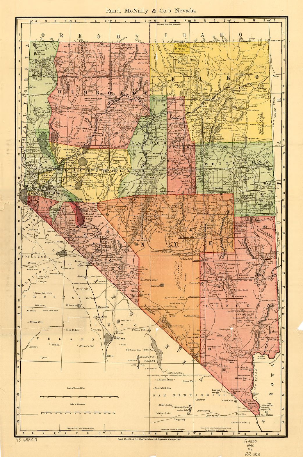
Indexed county and township pocket map and shippers guide of Nevada, accompanied by a new and origianl compilation and ready reference index, showing in detail the entire railroad network.
Reference link: https://www.loc.gov/item/98688513/
Reference note
Summary: Shows relief by hachures, drainage, counties, township lines, Indian reservations, roads, and railroads with names. Title from cover.
Contributor Names: Rand McNally and Company.
Created / Published: Chicago, 1893.
Subject Headings: - Nevada--Maps
- United States--Nevada
Notes: - Scale ca. 1:750,000.
- LC Railroad maps, 253
- Description derived from published bibliography.
- Available also through the Library of Congress Web site as a raster image.
Repository: Library of Congress Geography and Map Division Washington, D.C. 20540-4650 USA dcu
Digital Id: http://hdl.loc.gov/loc.gmd/g4350.rr002530
Interpreting Primary Sources with a Geographic Lens
Teaching Notes
Tools and resources for interpreting primary sources with a geographic lens.
Site by the Arizona Geographic Alliance Includes:
- Adapted Library of Congress Analysis tool which include geographic prompts for all media types
- Student Worksheets
- Additional Primary Source Sets for exploring geography
Excerpts from Settler Letters From the Book: The World Rushed In
Teaching Notes
Excerpted letters from settlers of the West.
Selected to provide first hand accounts of those involved in westward expansion.
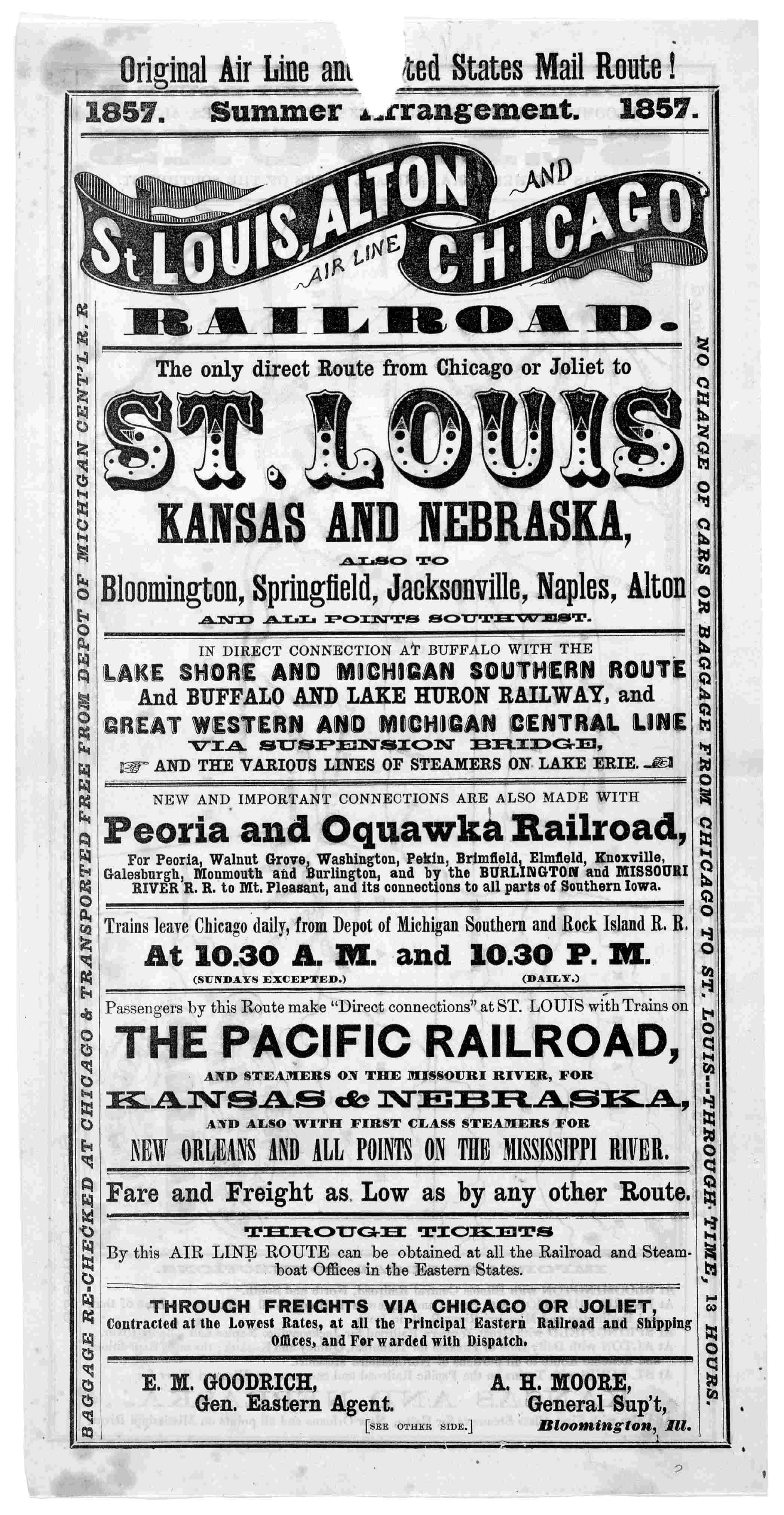
Image 1 of Original air line and United States mail route! 1857. Summer arrangement. 1857. St. Louis, Alton and Chicago air line railroad ... 1857. [Chicago? Ill.].
Reference link: http://www.loc.gov/resource/rbpe.01703600/
Reference note
Contributor Names: St. Louis, Alton and Chicago air line railroad.
Created / Published: Chicago, 1857.
Subject Headings: - United States--Illinois--Chicago
Genre: Advertisements--Illinois--Chicago
Notes: - Map of Illinois, Iowa, Nebraska, Kansas and Missouri on verso.; Transportation.; Map.
- Available also through the Library of Congress web site in two forms: as facsimile page images and as full text in SGML.
- Printed Ephemera Collection; Portfolio 17, Folder 36.
Digital Id: http://hdl.loc.gov/loc.rbc/rbpe.01703600
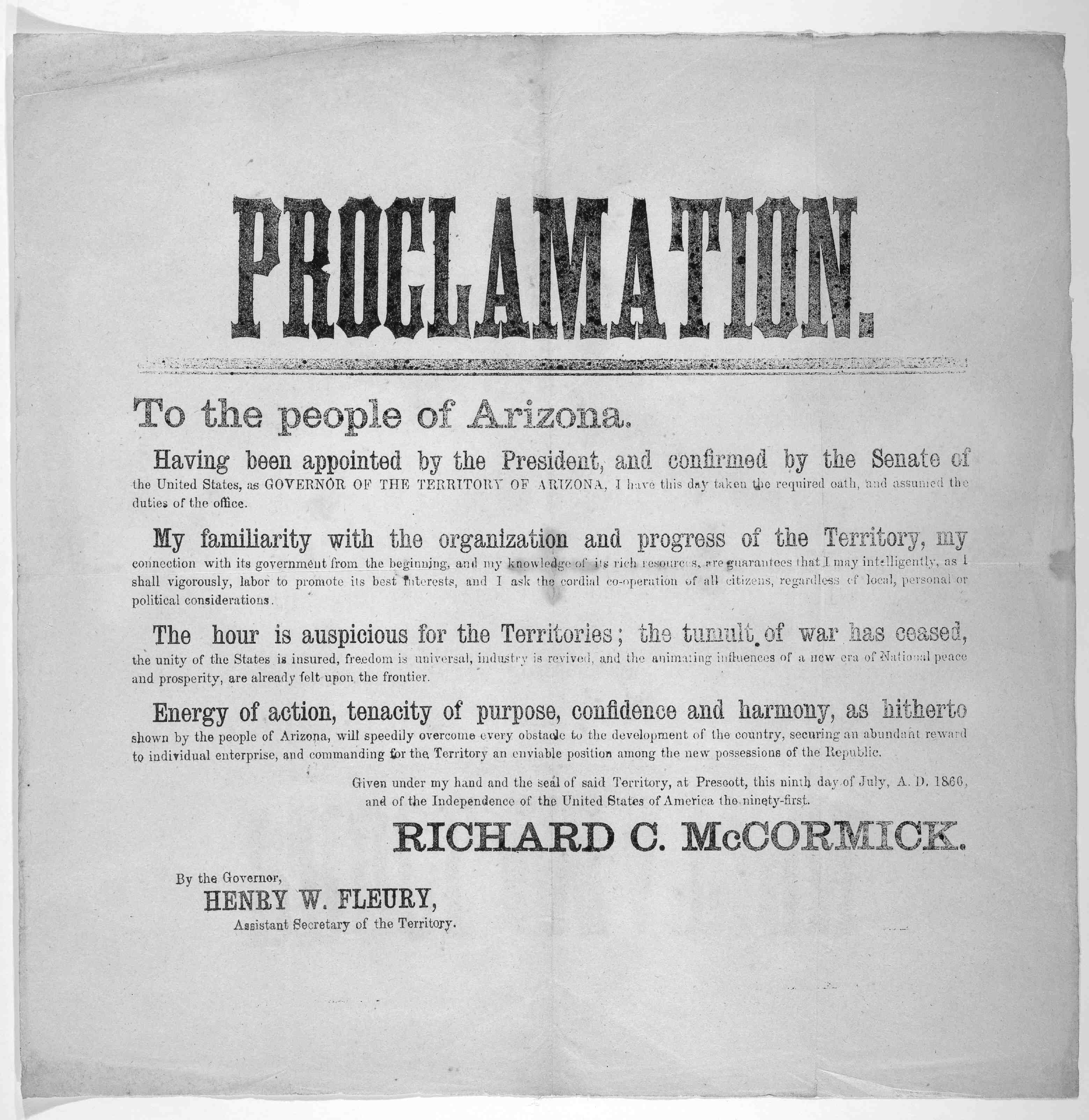
Proclamation to the people of Arizona. July 9, 1866.
Reference link: http://www.loc.gov/resource/rbpe.00103000/
Reference note
Contributor Names: Arizona. Territory. Governor. Richard C. McCormick.
Created / Published: Prescott, 1866.
Subject Headings: - United States--Arizona--Prescott
Genre: Proclamations--Arizona--Prescott
Notes: - Proclamation.
- Available also through the Library of Congress web site in two forms: as facsimile page images and as full text in SGML.
- Printed Ephemera Collection; Portfolio 1, Folder 30.
Digital Id: http://hdl.loc.gov/loc.rbc/rbpe.00103000
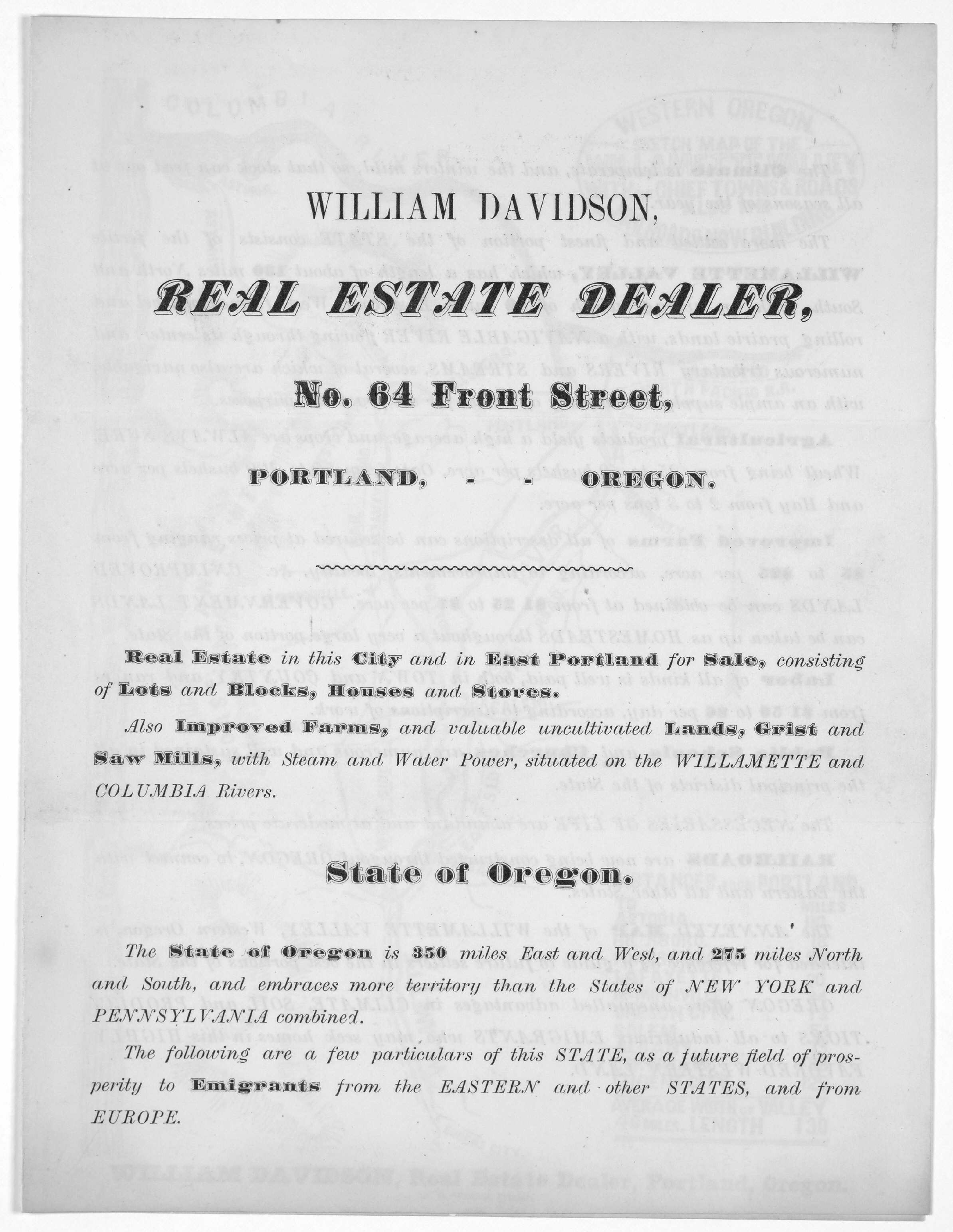
Image 1 of [Three broadsides, advertisements of William Davidson, real estate dealer of Portland Oregon 18- ].
Reference link: http://www.loc.gov/resource/rbpe.13901500/
Reference note
Contributor Names: Davidson, William.
Created / Published: Portland, 1800.
Subject Headings: - United States--Oregon--Portland
Genre: Leaflets--Oregon--Portland
Notes: - Page Order: Pieces 1 and 2 are Leaflets.
- Available also through the Library of Congress web site in two forms: as facsimile page images and as full text in SGML.
- Printed Ephemera Collection; Portfolio 139, Folder 15.
Digital Id: http://hdl.loc.gov/loc.rbc/rbpe.13901500
I will go west!
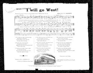
Reference link: https://www.loc.gov/resource/sm1875.10352.0
Reference note
Contributor Names: Barrett, J. P.
Created / Published: Butler, J. A., Boston, 1875, monographic.
Subject Headings: - Choruses, Secular (Mixed voices, 4 parts), Unaccompanied
Genre: sheet music
Notes: - From: Music Copyright Deposits, 1870-1885 (Microfilm M 3500)
- Also available through the Library of Congress Web Site as facsimile page images. (additional physical form)
Repository: Library of Congress. Music Division.
The North Platte semi-weekly tribune., April 20, 1920, Image 4
Teaching Notes
Where Wheat is King
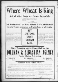
Reference note
Newspaper: The North Platte semi-weekly tribune. (North Platte, Neb.) 1895-1922Newspaper Link: https://chroniclingamerica.loc.gov/lccn/2010270504/1920-04-20/ed-1/seq-4
Image provided by: University of Nebraska-Lincoln Libraries, Lincoln, NE
PDF Link: https://chroniclingamerica.loc.gov/lccn/2010270504/1920-04-20/ed-1/seq-4.pdf
Imperial Valley press., January 08, 1910, Page 2, Image 2
Teaching Notes
Townsite Opening
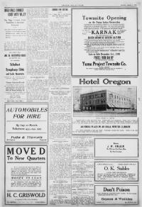
Reference link: https://chroniclingamerica.loc.gov/lccn/sn92070146/1910-01-08/ed-1/seq-2/print/image_681x632_from_2146%2C0_to_5202%2C2837
Reference note
Newspaper: Imperial Valley press. (El Centro, Calif.) 1907-currentNewspaper Link: https://chroniclingamerica.loc.gov/lccn/sn92070146/1910-01-08/ed-1/seq-2/print/image_681x632_from_21...
Image provided by: University of California, Riverside; Riverside, CA
PDF Link: https://chroniclingamerica.loc.gov/lccn/sn92070146/1910-01-08/ed-1/seq-2.pdf
Omaha daily bee., October 23, 1910, WANT ADS, Page 8, Image 46
Teaching Notes
You’ll find your opportunity in the new West
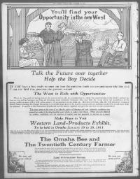
Reference note
Newspaper: Omaha daily bee. (Omaha [Neb.]) 187?-1922Newspaper Link: https://chroniclingamerica.loc.gov/lccn/sn99021999/1910-10-23/ed-1/seq-46
Image provided by: University of Nebraska-Lincoln Libraries, Lincoln, NE
PDF Link: https://chroniclingamerica.loc.gov/lccn/sn99021999/1910-10-23/ed-1/seq-46.pdf
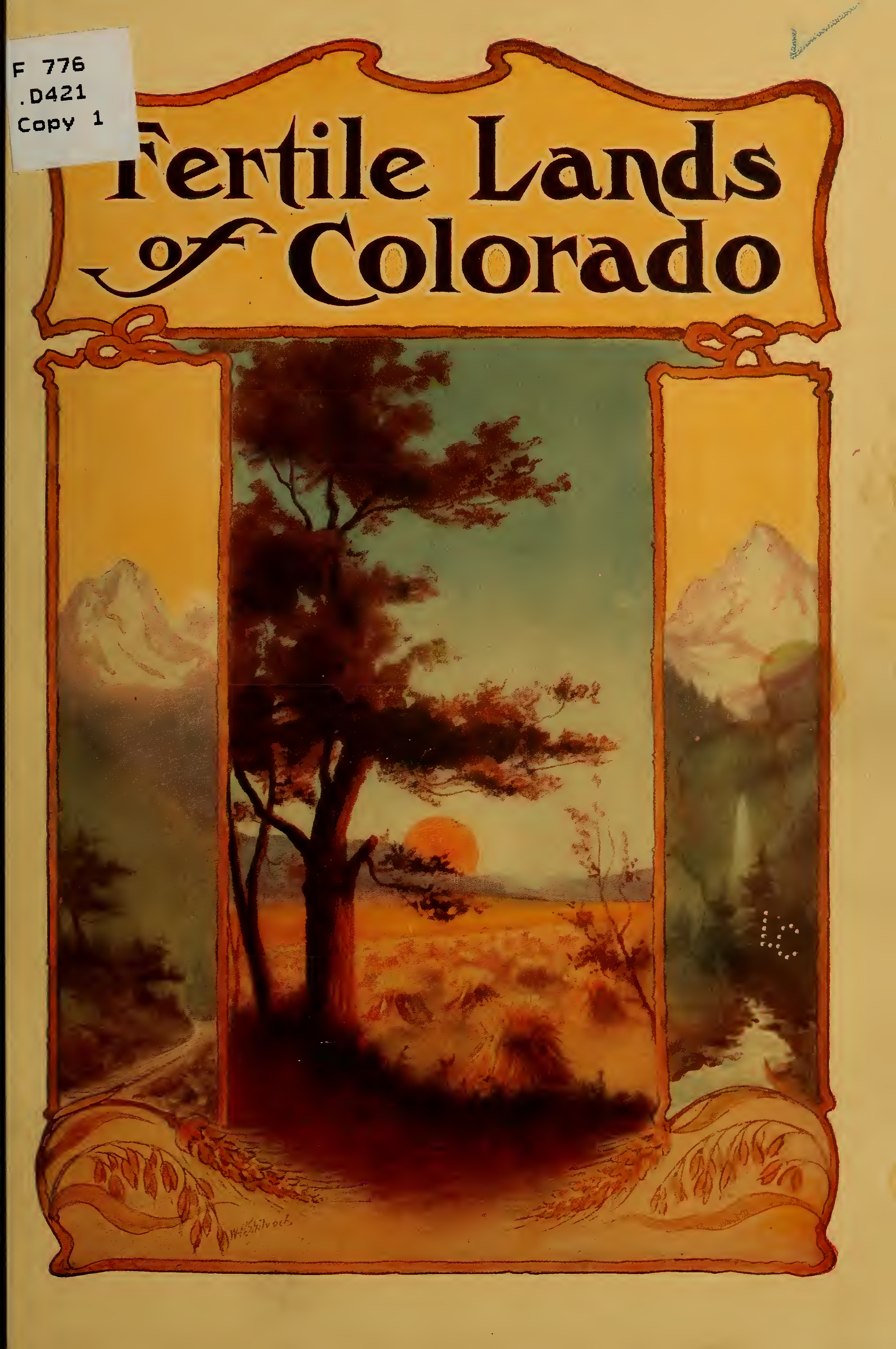
The fertile lands of Colorado and northern New Mexico
Teaching Notes
Corporate name
Denver and Rio Grande Railroad Company.
Main title
The fertile lands of Colorado and northern New Mexico ... written by Charles A. Lyman.
Edition
12th ed., 235,000 copies.
Published/Created
[Denver?] Passenger Dept., the Denver & Rio Grande Railroad, c1912.
How the public domain has been squandered, map showing the 139,403,026 acres of the people's land - equal to 871,268 farms of 160 acres each, worth at $2 an acre, $278,806,052, given by Republican Congresses to railroad corporations
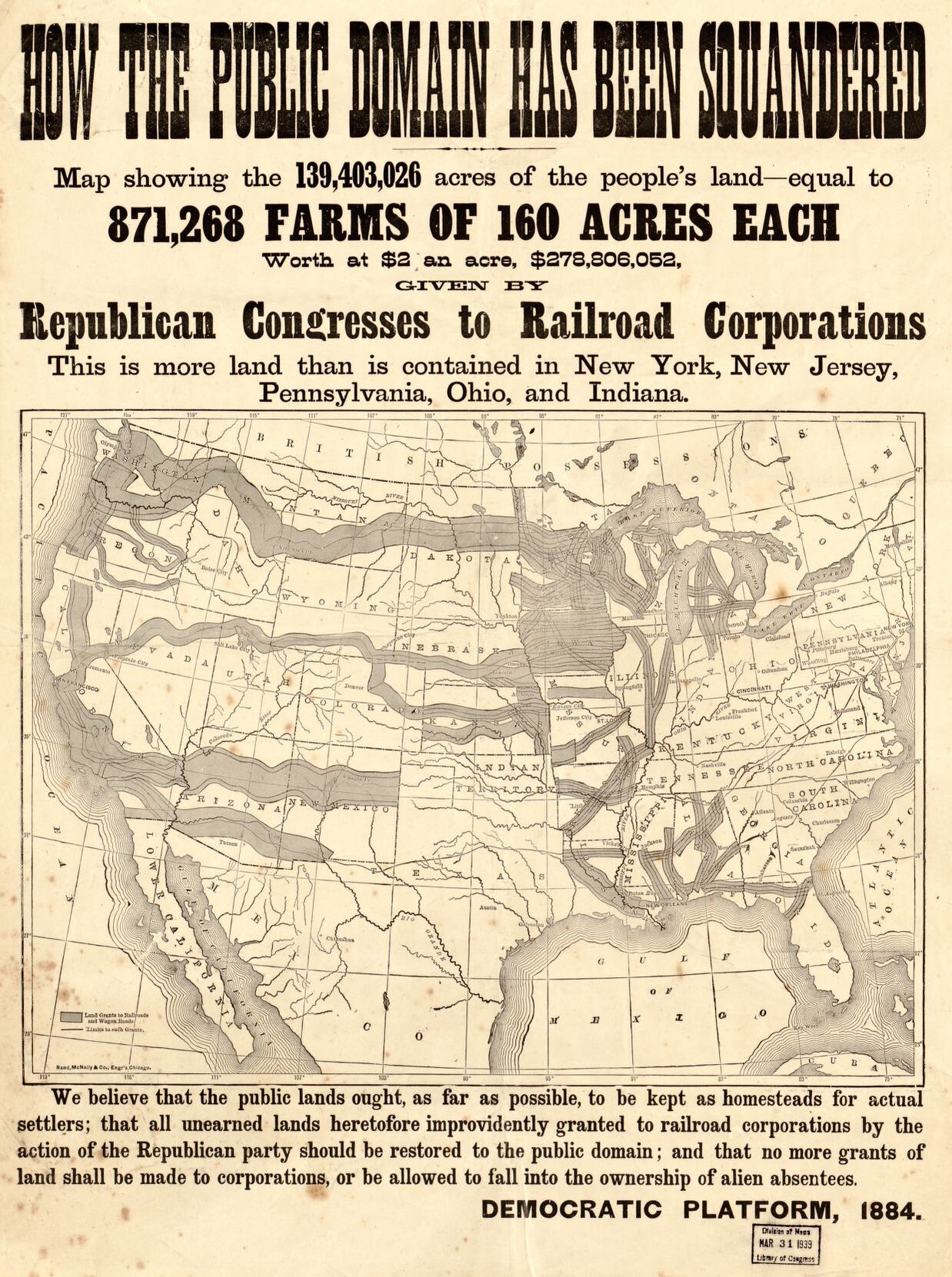
Reference link: https://www.loc.gov/item/2006627679/
Reference note
Contributor Names: Rand McNally and Company.
Created / Published: Chicago : Rand McNally and Company, 1884.
Subject Headings: - Transportation--United States--Maps
- United States
Notes: - On sheet below map "We believe that the public lands ought, as far as possible, to be kept as homesteads for actual settlers; that all unearned lands heretofore improvidently granted to railroad corporations by the action of the Republican party should be restored to the public domain; and that no more grants of land shall be made to corporations, or be allowed to fall into the ownership of alien absentees. Democratic platform, 1884."
- Exhibition: Maps for an Emerging Nation: Commercial Cartography in Nineteenth-century America, Aug. 8-Oct. 20, 1977 .
- Available also through the Library of Congress Web site as a raster image.
Repository: Library of Congress Geography and Map Division Washington, D.C. 20540-4650 USA dcu
Digital Id: http://hdl.loc.gov/loc.gmd/g3701p.ct001467
Map of land-grant and bond-aided railroads of the United States.
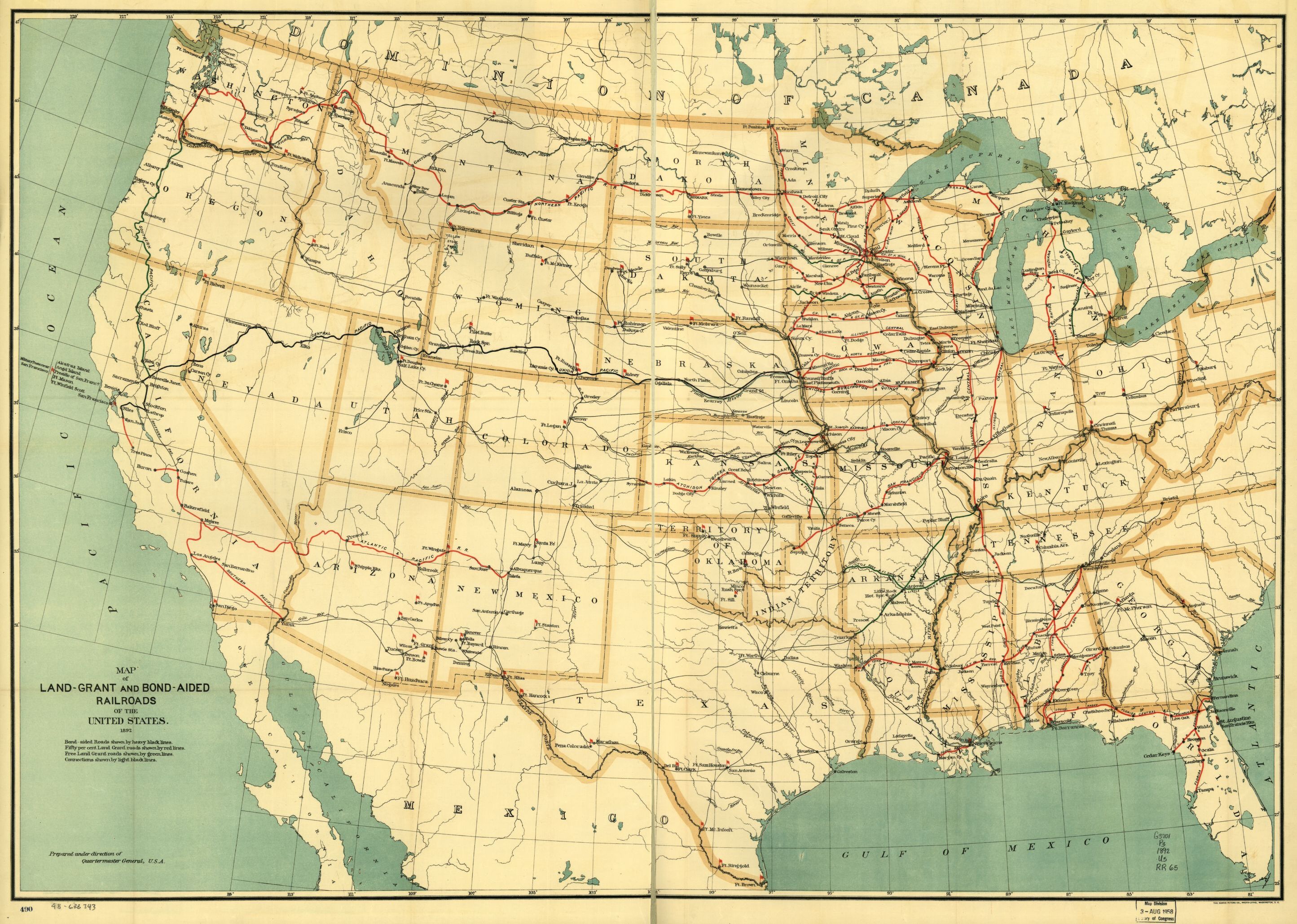
Reference link: https://www.loc.gov/item/98688343/
Reference note
Summary: Outline map of the United States showing major drainage, cities and towns, and military posts.
Contributor Names: United States. Army. Quartermaster Corps.
Created / Published: Washington, 1892.
Subject Headings: - Railroads--United States--Maps
- Railroad land grants--United States--Maps
- Military bases--United States--Maps
- United States
Notes: - Scale ca. 1:5,000,000.
- "Bond-aided roads shown by heavy black lines. Fifty per cent land grant roads shown by red lines. Free land grant roads shown by green lines. Connections shown by light black lines."
- LC Railroad maps, 65
- Description derived from published bibliography.
- Available also through the Library of Congress Web site as a raster image.
Repository: Library of Congress Geography and Map Division Washington, D.C. 20540-4650 USA dcu
Digital Id: http://hdl.loc.gov/loc.gmd/g3701p.rr000650
Map showing the new transcontinental route of the Atlantic & Pacific Railroad and its connections.
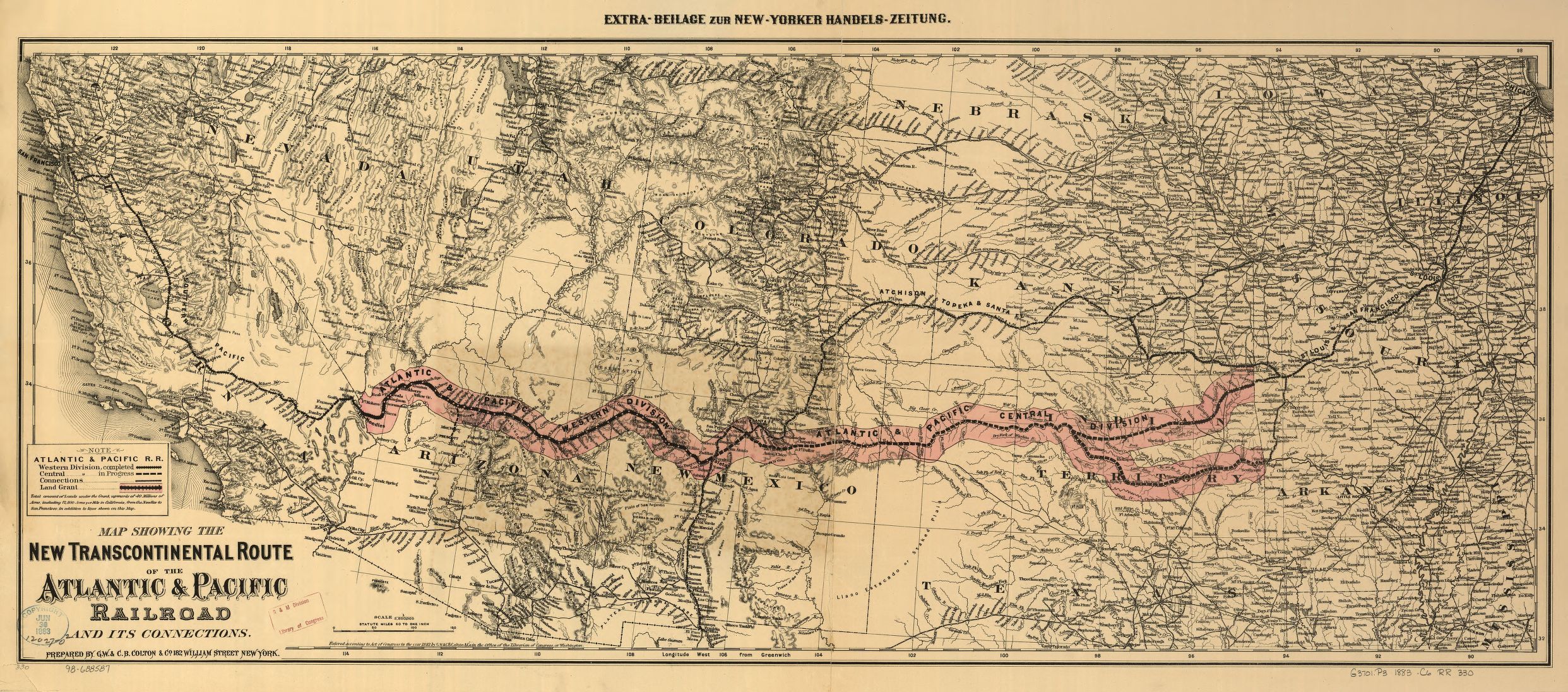
Reference link: https://www.loc.gov/item/98688587/
Reference note
Summary: Map covering the southwestern states but extending from Chicago to the Pacific Coast.
Contributor Names: G.W. & C.B. Colton & Co.
Atlantic and Pacific Railroad Company.
Chicago & Pacific Railroad.
Created / Published: New York, 1883.
Subject Headings: - Atlantic and Pacific Railroad Company--Maps
- Chicago & Pacific Railroad--Maps
- Railroads--United States--Maps
- Railroad land grants--United States--Maps
- United States
Notes: - 12027 U.S. Copyright Office
- Scale ca. 1:3,800,000.
- LC Railroad maps, 330
- Description derived from published bibliography.
- Shows relief by hachures, drainage, cities and towns, township lines, the land grant of the "western division," railroads in progress of completion, and completed lines with their connections.
- At top of map: Extra-Beilag zue New-Yorker Handels-Zeitung.
- Available also through the Library of Congress Web site as a raster image.
Repository: Library of Congress Geography and Map Division Washington, D.C. 20540-4650 USA dcu
Digital Id: http://hdl.loc.gov/loc.gmd/g3701p.rr003300
Lloyd's American railroad map of the United States, showing the three proposed roads and the overland mail route to the Pacific,
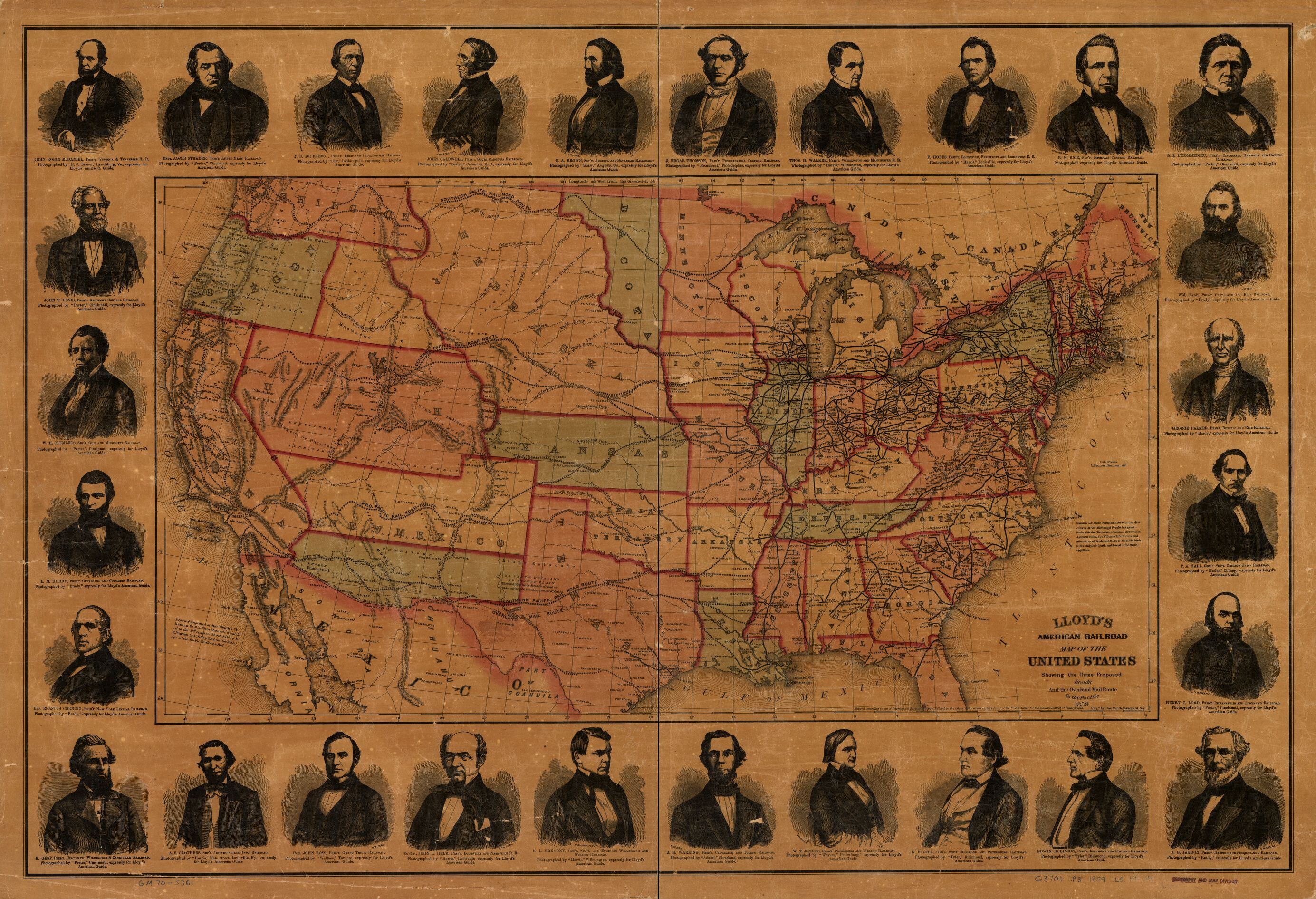
Reference link: https://www.loc.gov/item/gm70005361/
Reference note
Summary: Outline map of the continental United States showing drainage, state boundaries, major cities, forts, finished and proposed railroads. [From published bibliography]
Contributor Names: Lloyd, James T.
Smith, Rae.
Created / Published: [New York], 1859.
Subject Headings: - Railroads--United States--Maps
- United States
Notes: - Scale ca. 1:6,500,000.
- Relief shown by hachures.
- Portraits of 28 railroad presidents are reproduced in the border, including: John Robin McDaniel, Jacob Strader, J. D. De Frees, John Caldwell, C. A. Brown, J. Edgar Thompson, Thos. D. Walker, E. Hobbs, R. N. Rice, S. S. L'Hommedieu, Wm. Case, George Palmer, P. A. Hall, Henry C. Lord, A. G. Jaudon, Edwin Robinson, E. H. Gill, W. T. Joynes, J. B. Warring, S. L. Fremont, John L. Helm, John Ross, A. S. Crothers, E. Gest, Erastus Corning, L. M. Hubby, W. H. Clements, John T. Levis,
- "Entered according to act of Congress in the year 1859 by J.T. Lloyd in the clerk's office of the District Court of the United States ..."
- "Drawn & engraved at Rae Smith's ... N.Y. from materials furnished to the 36th Congress, March 1859 by G.K. Warren, Lt. U.S. Top. Eng. for the passage of the Pacific Railroad bill."
- LC U.S. railroad maps, 37
- Includes portraits of 28 railroad presidents.
- Available also through the Library of Congress Web site as a raster image.
- AACR2
Repository: Library of Congress Geography and Map Division Washington, D.C. 20540-4650 USA dcu
Digital Id: http://hdl.loc.gov/loc.gmd/g3701p.rr000370
Indexed map of Colorado showing the railroads in the state, and the express company doing business over each, also counties and rivers.
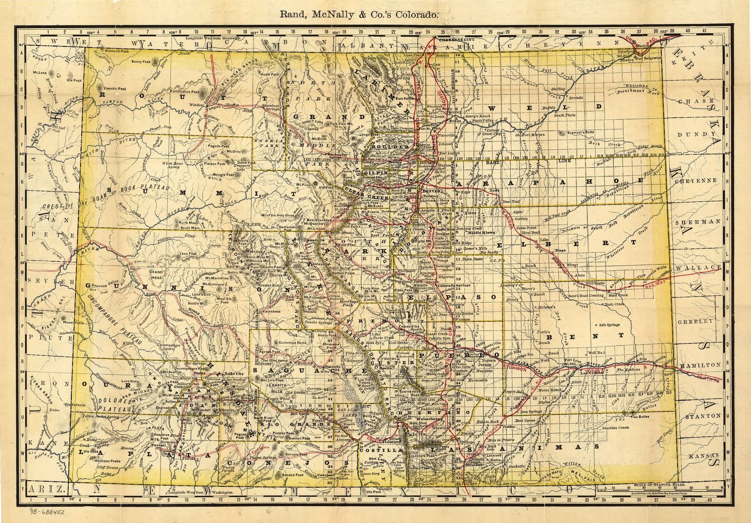
Reference link: https://www.loc.gov/item/98688452/
Reference note
Summary: Shows relief by hachures, drainage, counties, cities and towns, roads, and the railroads with names along the lines. Title from cover.
Contributor Names: Rand McNally and Company.
Created / Published: Chicago, 1879.
Subject Headings: - Colorado--Maps
- United States--Colorado
Notes: - Scale ca.1:1,500,000.
- LC Railroad maps, 190
- Description derived from published bibliography.
- Available also through the Library of Congress Web site as a raster image.
Repository: Library of Congress Geography and Map Division Washington, D.C. 20540-4650 USA dcu
Digital Id: http://hdl.loc.gov/loc.gmd/g4310.rr001900
End of track, on Humboldt Plains
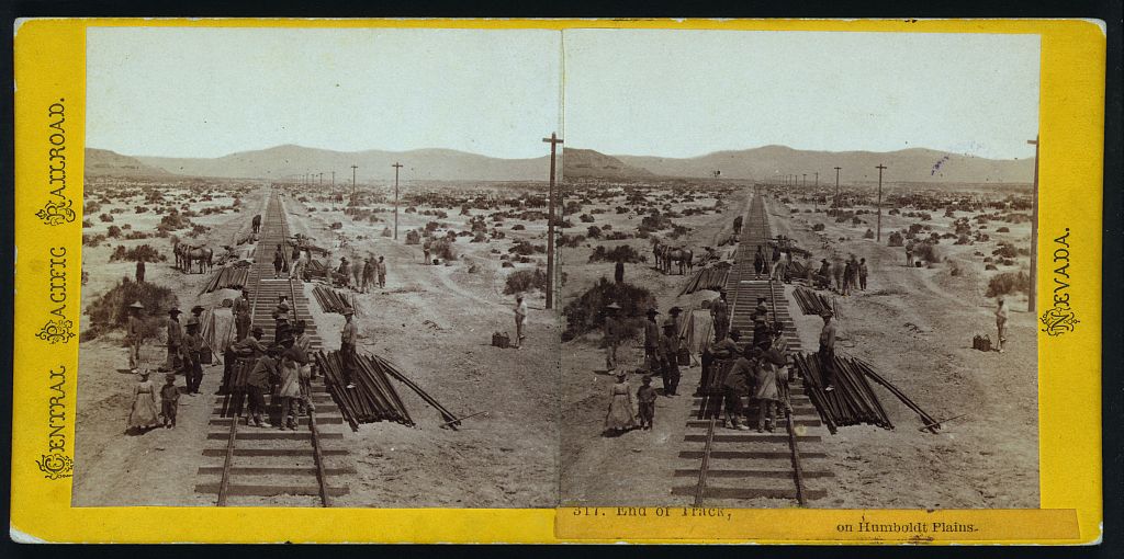
Reference link: https://www.loc.gov/pictures/item/2005683011/
Reference note
Creator(s): Hart, Alfred A., 1816-1908, photographer
Date Created/Published: Sacramento, Calif. : Golden State Photographic Gallery, [between 1865 and 1869]
Summary: Photo shows railroad track construction, including Chinese railroad workers.
Call Number: LOT 11477, no. 171 [item] [P&P]
Repository: Library of Congress Prints and Photographs Division Washington, D.C. 20540 USA
Notes: No. 317. Title from item. Part of series: Central Pacific Railroad, Nevada. Scenes on the Humboldt River.
Subjects: Railroad construction--Nevada--1860-1870.
Indexed map of Arizona showing the stage lines, counties, lakes & rivers.
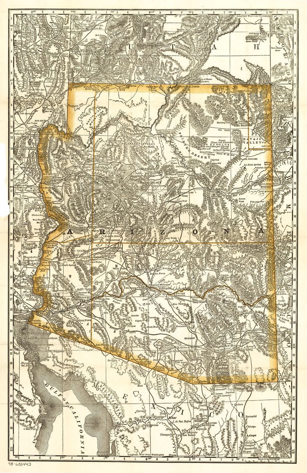
Reference link: https://www.loc.gov/item/98688443/
Reference note
Summary: Shows relief by hachures, cities and towns, roads and trails, proposed mail route, and proposed railroad lines.
Contributor Names: Rand McNally and Company.
Created / Published: Chicago, 1876.
Subject Headings: - Arizona--Maps
- United States--Arizona
Notes: - Scale ca. 1:2,000,000.
- Title from cover.
- LC Railroad maps, 181
- Description derived from published bibliography.
- Available also through the Library of Congress Web site as a raster image.
Repository: Library of Congress Geography and Map Division Washington, D.C. 20540-4650 USA dcu
Digital Id: http://hdl.loc.gov/loc.gmd/g4330.rr001810
New and correct map of the lines of the Northern Pacific Railroad and Oregon Railway & Navigation Co.
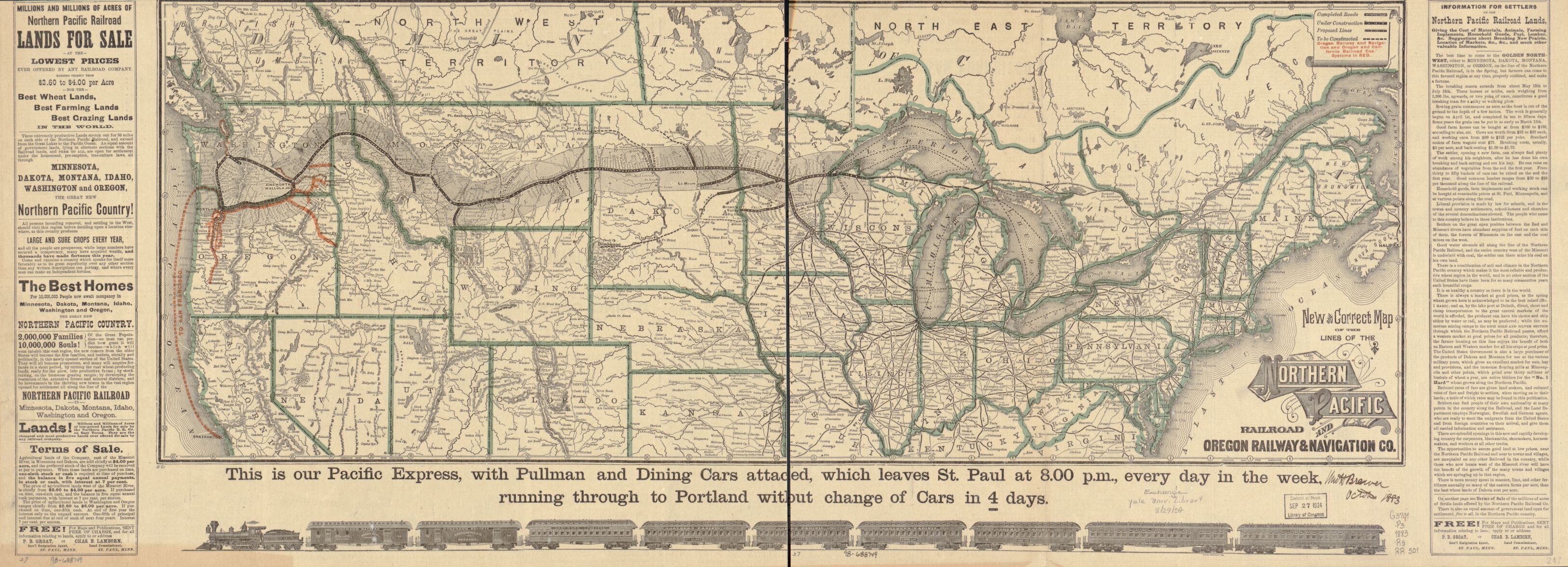
Reference link: https://www.loc.gov/item/98688749/
Reference note
Summary: Map of northern United States and part of Canada showing relief by hachures, drainage, cities and towns, and railroads. Shaded area shows land grant. Main lines indicated by heavy black and red.
Contributor Names: Rand McNally and Company.
Northern Pacific Railroad Company.
Created / Published: Chicago, 1883.
Subject Headings: - Northern Pacific Railroad Company--Maps
- Railroads--United States--Maps
- United States
Notes: - Scale ca. 1:6,000,000.
- Signed in ms: "Wm H Brewer October 1883."
- An uncolored facsimile edition of this map was published by Rand McNally and Company in celebration of their centennial in 1956.
- Information missing from center of map due to trimming.
- LC Railroad maps, 501
- Description derived from published bibliography.
- Available also through the Library of Congress Web site as a raster image.
Repository: Library of Congress Geography and Map Division Washington, D.C. 20540-4650 USA dcu
Digital Id: http://hdl.loc.gov/loc.gmd/g3701p.rr005010
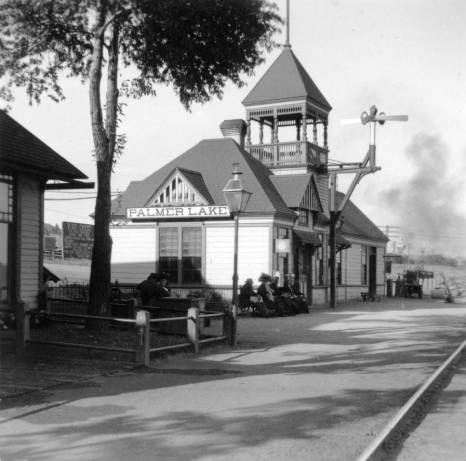
Palmer_Lake_railroad_station.jpg
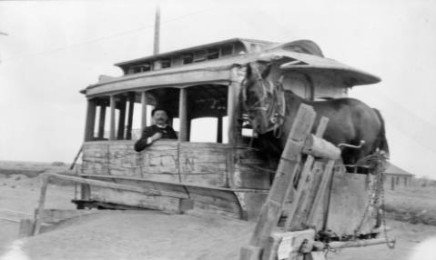
Cherrelyn_horsecar.jpg
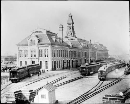
Old_Union_Station_Denver_Colo.jpg
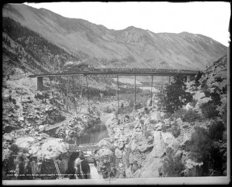
High_Bridge_over_the_Loop_above_Georgetown_Colo_C__S_Ry.jpg
Dalles
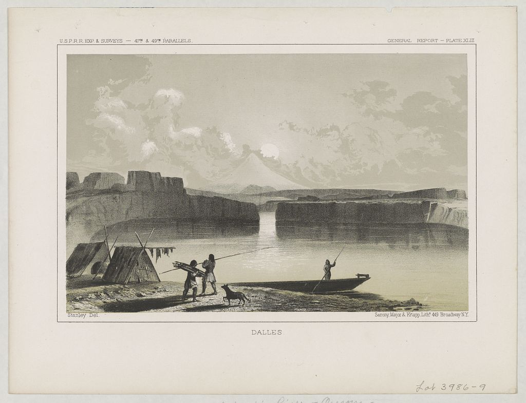
Reference link: https://www.loc.gov/pictures/item/95513912/
Reference note
Creator(s): Sarony, Major & Knapp Lith.,
Date Created/Published: [ca. 1855]
Summary: Print shows three Natives at a camp on the shore of The Dalles, on the Columbia River, Oregon.
Call Number: LOT 3986-9 [item] [P&P]
Repository: Library of Congress Prints and Photographs Division Washington, D.C. 20540 USA http://hdl.loc.gov/loc.pnp/pp.print
Notes: Title from item. U.S.P.R.R. Exp. & Surveys 47th & 49th Parallels. General Report Plate XLIII. Illus. from: U.S. Pacific railroad explorations and surveys, 47th & 49th Parallels. General Report / U.S. Army, Corps of Topographical Engineers. House executive document 129, 33rd Congress, 1st session, plate XLIII. Exhibited: "Capitol Visitor Center" at the U.S. Capitol, Washington, D.C., 2012.
Subjects: Indians of North America--Oregon--Dalles--1850-1860. Indian encampments--Oregon--Dalles--1850-1860.
Dumping rock on jetty
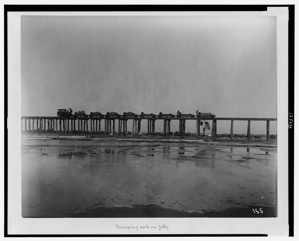
Reference link: https://www.loc.gov/pictures/item/00650204/
Reference note
Date Created/Published: [between 1890 and 1892(?)]
Summary: Train on jetty, Coos Bay, Oregon.
Call Number: LOT 5219 [item] [P&P]
Repository: Library of Congress Prints and Photographs Division Washington, D.C. 20540 USA
Notes: No. 10. On recto: No. 155. Engineering Department 1892.
Subjects: Jetties--Oregon--Coos Bay (Bay)--1890-1900. Railroads--Oregon--Coos Bay (Bay)--1890-1900. Rocks--Oregon--Coos Bay (Bay)--1890-1900.
Arrival of the first locomotive in Arizona
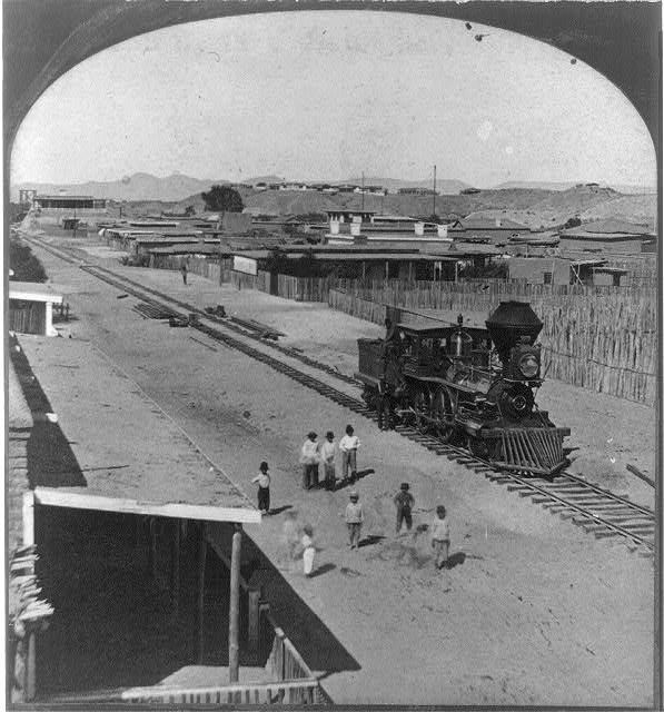
Reference link: https://www.loc.gov/pictures/item/2013645437/
Reference note
Date Created/Published: [United States] : Continent Stereoscopic Company, publishers, [1877]
Summary: Stereograph showing men posing on and near a locomotive, probably in Yuma, Arizona.
Call Number: LOT 13568, no. 11 [item] [P&P]
Repository: Library of Congress Prints and Photographs Division Washington, D.C. 20540 USA http://hdl.loc.gov/loc.pnp/pp.print
Notes: Written in pen on back of mount: Fort Yuma, Cal. on bluff in background. "Descriptive views of the American Continent" printed on mount. No. 254. Title from item.
Subjects: Railroad locomotives--Arizona--Yuma--1870-1880. Firsts--Arizona--Yuma--1870-1880.
Bridge across the Colorado River, at Yuma, Ariz.
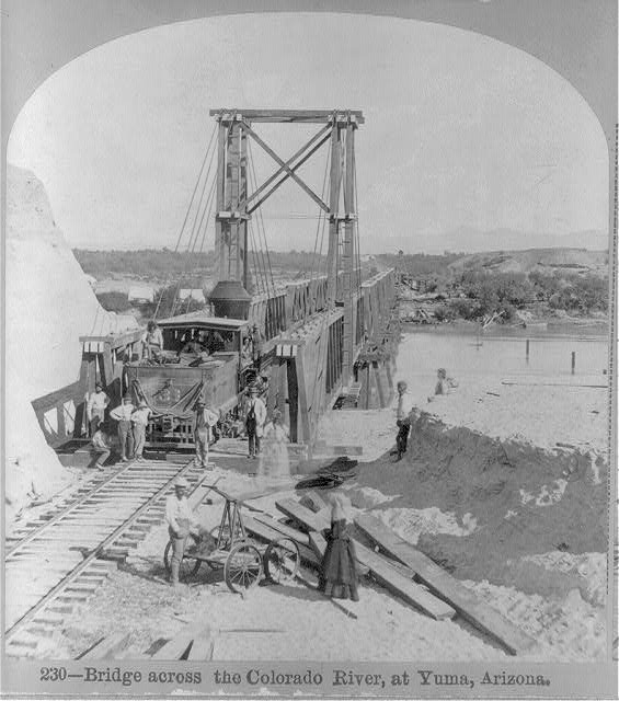
Reference link: https://www.loc.gov/pictures/item/2006687322/
Reference note
Date Created/Published: 1877.
Summary: Constructing railroad bridge, Arizona.
Call Number: LOT 13568, no. 7 [item] [P&P]
Repository: Library of Congress Prints and Photographs Division Washington, D.C. 20540 USA
Notes: Photo by E. Conklin; Continent Stereoscopic Co., Publishers. This record contains unverified, old data from caption card. Caption card tracings: Shelf.
Old "31" the Pioneer engine of Arizona
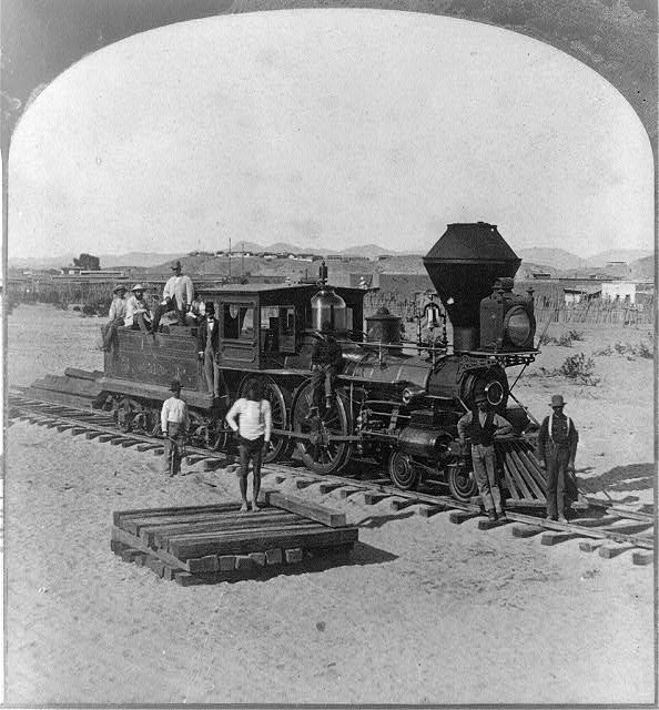
Reference link: https://www.loc.gov/pictures/item/2013645436/
Reference note
Date Created/Published: [United States] : Continent Stereoscopic Company, publishers, [1877]
Summary: Stereograph showing men posing on and near a locomotive, probably in Yuma, Arizona.
Call Number: LOT 13568, no. 9 [item] [P&P]
Repository: Library of Congress Prints and Photographs Division Washington, D.C. 20540 USA http://hdl.loc.gov/loc.pnp/pp.print
Notes: Written in pen on back of mount: Yuma, Ariz., Fort Yuma, Cal. on bluff in background. "Descriptive views of the American Continent" printed on mount. No. 237. Title from item.
Subjects: Railroad locomotives--Arizona--Yuma--1870-1880.
Santa Fe Eating House, Kingman, Arizona
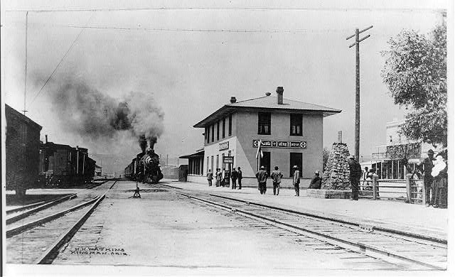
Reference link: https://www.loc.gov/pictures/item/2012649494/
Reference note
Creator(s): Watkins, H. H., photographer
Date Created/Published: [between ca. 1890 and ca. 1910]
Summary: Photograph shows people waiting on platform as train, with black smoke spewing from smoke stack, arrives at railroad station.
Call Number: SSF - Railroads -- Stations -- Arizona -- Kingman [item] [P&P]
Repository: Library of Congress Prints and Photographs Division Washington, D.C. 20540 USA http://hdl.loc.gov/loc.pnp/pp.print
Notes: H. H. Watkins, Kingman, Ariz. Title from item.
Subjects: Railroad stations--Arizona--Kingman--1890-1910.
1. Historic American Buildings Survey Photocopy Credit: Nevada State Museum SOUTH SIDE AND EAST FACADE, JUNE 16, 1882 - Virginia & Truckee Railroad Shops, Between Plaza, Ann, Stewart & Sophia Streets, Carson City, Carson City, NV
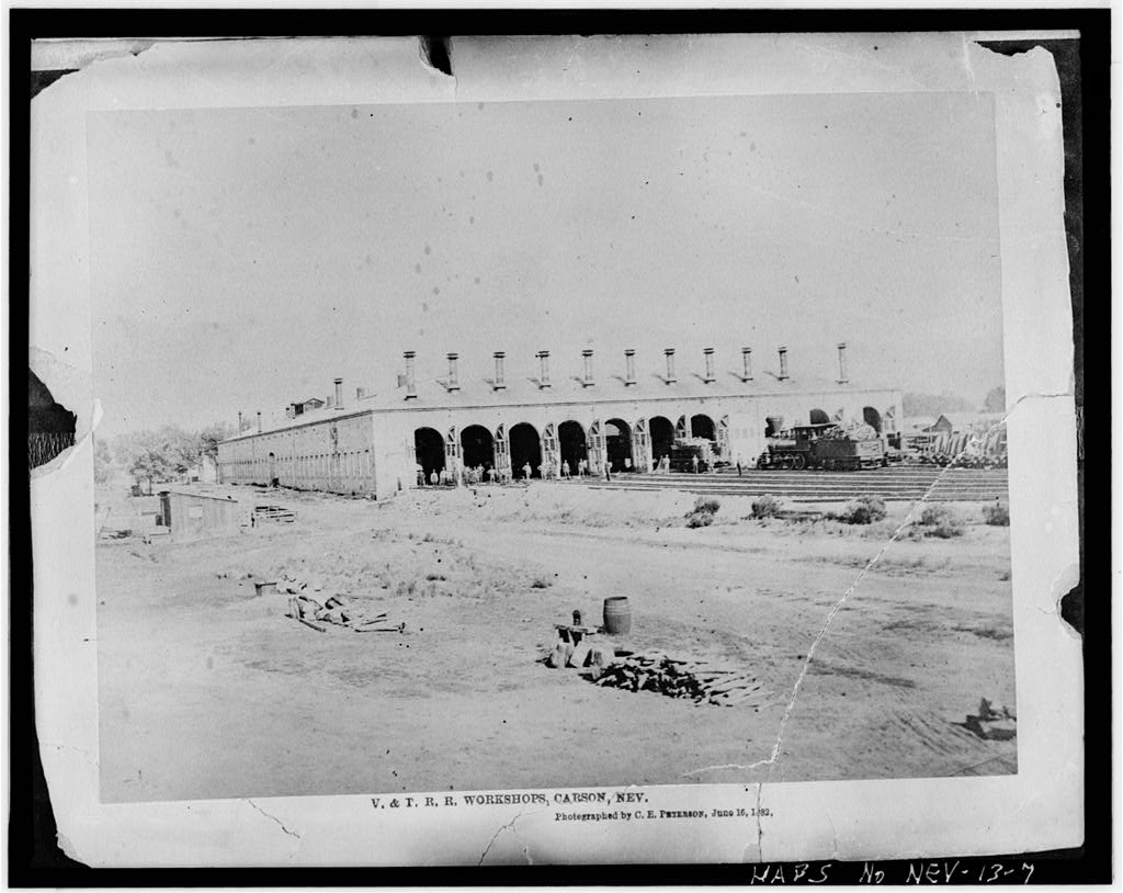
Reference link: https://www.loc.gov/pictures/item/nv0032.photos.104069p/
Reference note
Call Number: HABS NEV,13-CARCI,6--1
Repository: Library of Congress Prints and Photographs Division Washington, D.C. 20540 USA http://hdl.loc.gov/loc.pnp/pp.print
Summit of Sierra Nevada - snow sheds in foreground, Donner Lake in the distance, Central Pacific R.R.
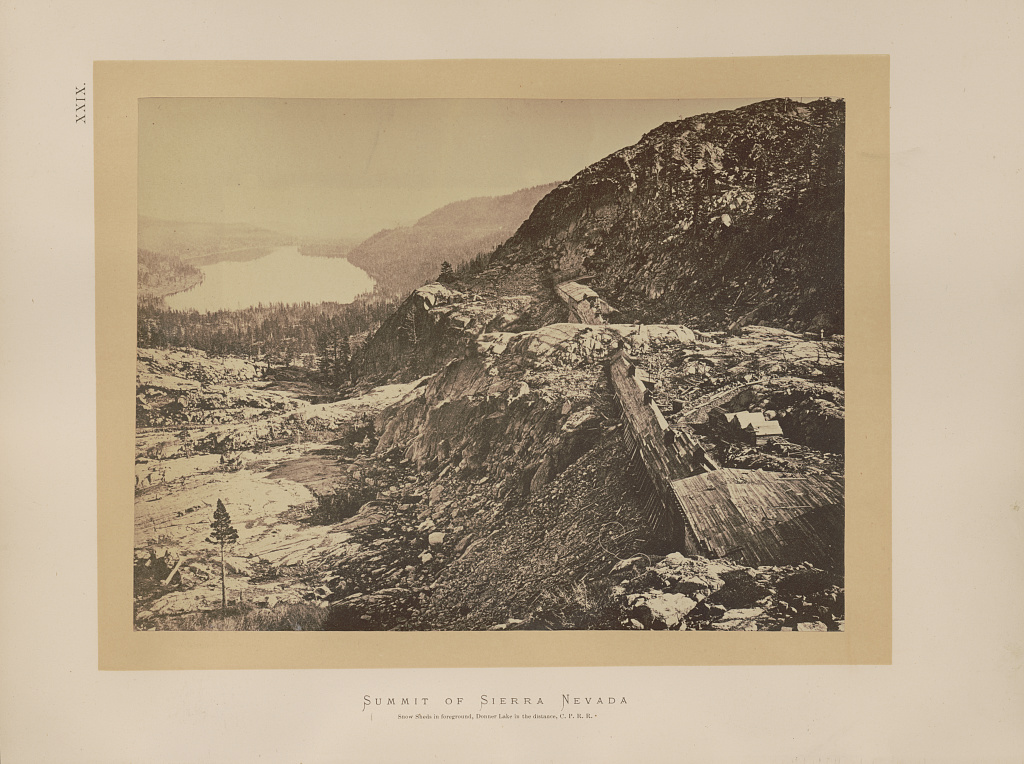
Reference link: https://www.loc.gov/pictures/item/2003668259/
Reference note
Creator(s): Russell, Andrew J., photographer
Date Created/Published: [1868]
Summary: Photograph shows snow sheds over railroad tracks between tunnels in the Sierra Nevada, with Donner Lake in the distance.
Call Number: Illus. in F594 .H41 (Case X) [P&P]
Repository: Library of Congress Prints and Photographs Division Washington, D.C. 20540 USA
Notes: Title from item. Illus. in: Sun pictures of Rocky Mountain scenery, with a description of the geographical and geological features, and some account of the resources of the great West; containing thirty photographic views along the line of the Pacific rail road, from Omaha to Sacramento, / F.V. Hayden. New York : Julius Bien, 1870, [plate] XXIX.
Subjects: Central Pacific Railroad Company--Facilities--California--1860-1870. Snowsheds--California--1860-1870. Railroad construction & maintenance--California--1860-1870. Railroad tunnels--California--1860-1870. Mountains--California--1860-1870. Lakes & ponds--California--1860-1870. Sierra Nevada (Calif. and Nev.)--1860-1870. Donner Lake (Calif.)--1860-1870.